Traveling from the capital of the federal government to the capital of the automobile industry, we arrive at the largest U.S. city on the Canadian border. Detroit, Michigan has been known for its spectacular rise and fall throughout the 20th century. The “Motor City” was not only an enormous hub for the car industry, but also home to Motown, which launched the careers of many famous African-American musicians. Detroit is also home to many professionals sports teams (the Lions, Pistons, Tigers, and Red Wings) who each have their cohort of die-hard fans. Detroit is also a “melting pot” of many peoples from around the world, and there are a slew of ethnic restaurants bound to satisfy anyone’s taste (Chinese, Greek, Italian, Mexican, Middle Eastern, and Polish eateries abound).
Yet in spite of all these assets, Detroit struggled mightily during the latter half of the 20th century. The population declined from a peak of 1.86 million in 1950 to a little over 700,000 today. It’s no surprise that most major cities in the so-called “Rust Belt” saw major declines over the last 60 years, but Detroit was hit especially hard. If you ask people why Detroit has had such problems in recent decades, you are bound to find multiple answers: from automation in the automobile industry, to racial tensions and the urban riots of the 1960s, to corporate greed, to the decline of unions (or stranglehold of unions, depending on who you ask), to the accusations of corruption and incompetence of city governments over the years. The fallout from all these events have led to a particular bitterness and hostility between different sides in Detroit’s politics. Is there a way out? Possibly. Efforts are under way to revitalize the city, and perhaps there may come a day when Detroiters can overcome their differences and work together to get the Motor City back on its feet.
It should surprise no one that Detroit, being the hub of the nation’s auto industry, was way ahead of other cities when it came to planning high-speed motorways: the city can arguably claim to have built the first urban expressway in the United States. As a result, the Davison Freeway has had a longer history, with more twists and turns, than the other projects that have been covered so far on this site.
The story of the Davison starts way back in 1940. At that time, Davison Avenue was a busy corridor, shuttling commuters back and forth between Detroit and its northern suburb of Highland Park. Traffic had reached a point of gridlock, and in 1941 the Highland Park city council voted to rebuild the road as a freeway, and demolition commenced for over 130 homes located along the avenue. By the end of 1942, the freeway was completed and opened to traffic, with a total length of 7000 feet (about 1.25 miles long).
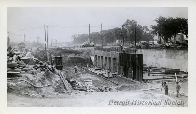
Demolition and widening of Davison Avenue during freeway construction.
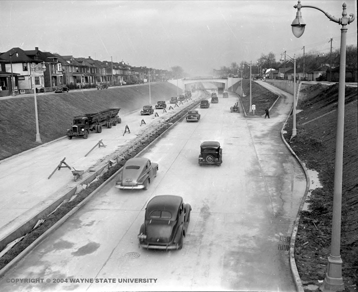
The Davison Freeway shortly after being opened to traffic.
The Davison was only a drop in the bucket to what was planned for the city of Detroit. Even before the end of World War 2, Detroit already had plans on the board for multiple expressways to cross every section of the city.
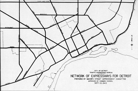
As the 1940s and the 1950s passed, Detroit scaled back its freeway plans somewhat, and the layout started to resemble the network that is in place today:
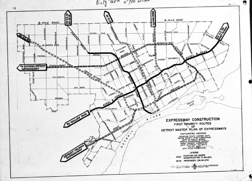
As you can tell from the above maps, the Davison Freeway was only the start of what was to come. The Vernor and Conner Freeways were never built, and opposition to the proposed freeway along Grand River Avenue later caused I-96 to be re-routed along Schoolcraft instead. In 1957 the Davison Freeway was extended west to connect with the newly-opened Lodge Freeway (U.S. Highway 10), and in 1968 was extended east to Conant Street, also connecting with the I-75/Chrysler Freeway, which had just been finished. The Davison had now more than doubled in total length to 2.85 miles. Although plans for some of the other freeways in Detroit had been scrapped by the late 1960s, transportation planners were hoping to extend the Davison Freeway further west to meet up with I-96, as well as further east to Mound Road.
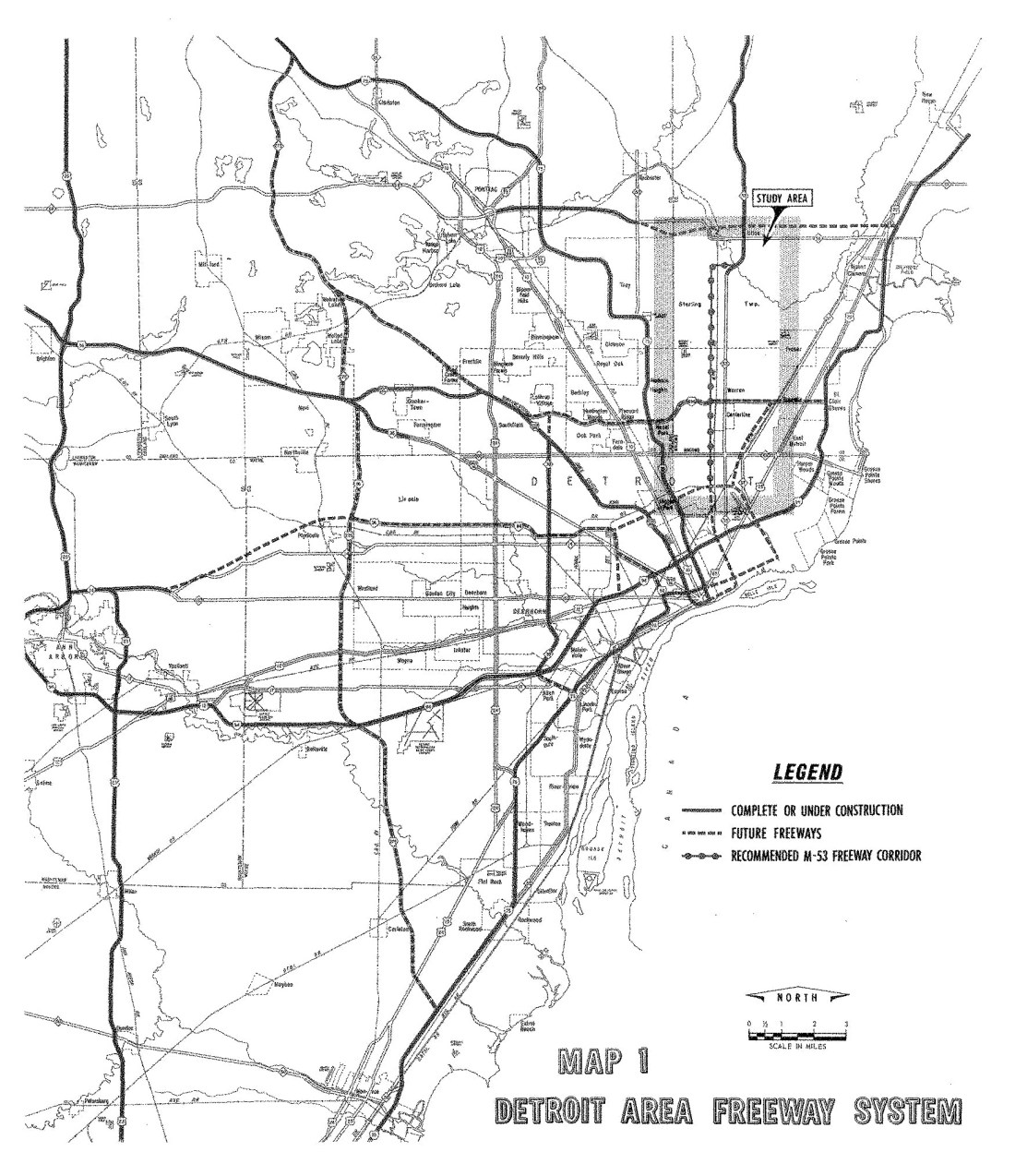
1967 Michigan DOT plans for the Detroit/Ann Arbor freeway system. Note the plans to extend the Davison further west and east, along with a greatly (!) extended M-53/Van Dyke Freeway that would have run to the edge of downtown Detroit.
As late as 1973, E.V. Erickson, who was the chairman of the State High Commission in Michigan, advocated for the extension of the Davison, along with 13 other freeways throughout the state. The proposed highways were to be built using funds from Governor William Milliken’s transportation package. However, local opposition to further freeway construction, which had been brewing for years, led Mayor Coleman Young and the Detroit City Council to ax the extension for the Davison.
By the mid-1990s, questions arose as to what the fate of the Davison would be. The freeway was closed by that point, due to the antiquated and unsafe conditions of the road: high volume of traffic , no shoulders, narrow lanes and a narrow median had all conspired to make the Davison unable to meet modern safety rules and regulations. Incredibly the original concrete had held up well over its 50-year lifespan. What to do? There was some talk of filling in the depressed freeway and converting the Davison back into a city avenue, although, interestingly enough, there was significant opposition to this idea by residents of both Detroit and Highland Park. After some back-and-forth political tussling between Governor John Engler and local leaders, the Davison was renovated as a modern-day eight-lane freeway, with wider shoulders and a concrete barrier in the median. Maintenance of the highway was transferred from local to state control, and the Davison was thus designated as Michigan State Route 8. The re-constructed freeway was re-opened to traffic in 1997.
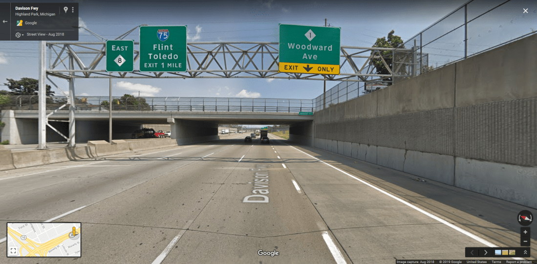
Facing eastward on the reconstructed Davison Freeway.
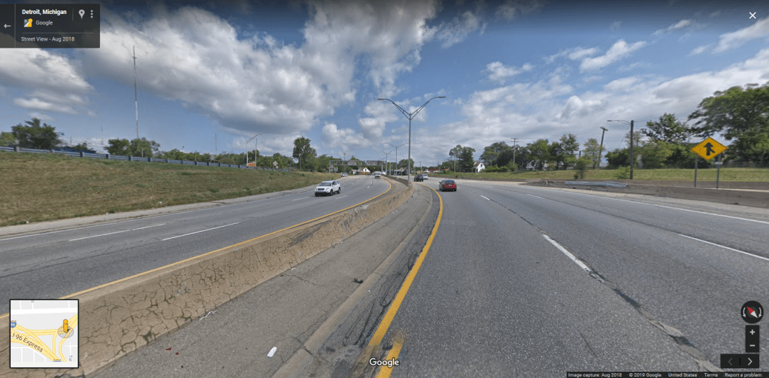
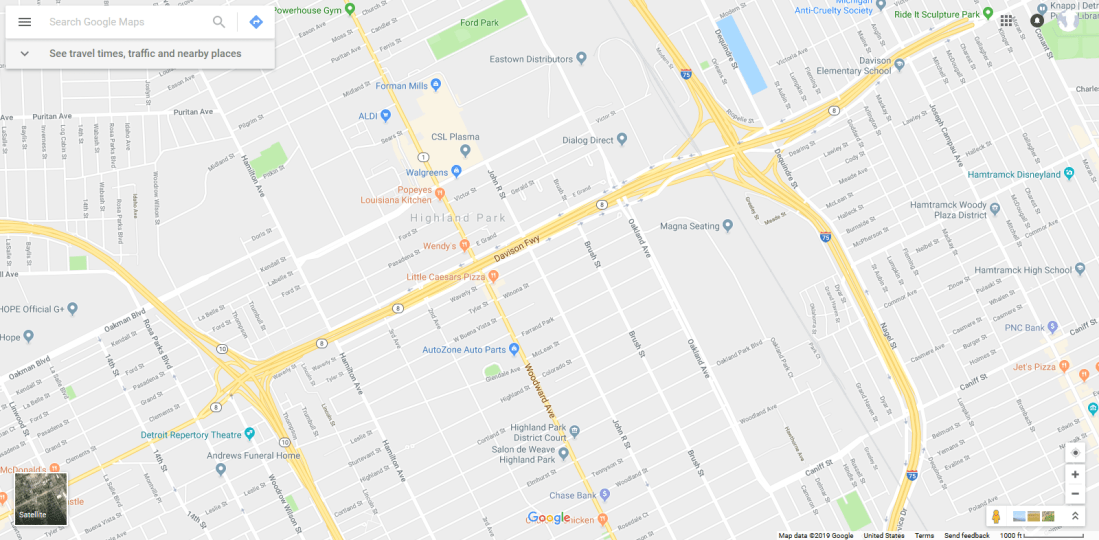
Facing east at the I-96/Davison Avenue interchange. Note the presence of the wide median, multiple lanes, and on/off-ramps — evidence that the Davison Freeway was originally planned to extend further west to I-96.
Additional sources:
http://www.atdetroit.net/forum/messages/6790/43221.html?1159540884
http://www.dailydetroit.com/2016/08/03/detroit-home-americas-first-urban-freeway/
https://www.michigan.gov/documents/mdot/RR168PL_168_534100_7.pdf
http://www.michiganhighways.org/listings/M-008.html
https://en.wikipedia.org/wiki/M-8_(Michigan_highway)
Holland Evening Sentinel – March 12, 1973 – page 7
https://en.wikipedia.org/wiki/Highway_revolts_in_the_United_States#Detroit
