In light of recent changes in my life, I decided that the previous post would be better suited somewhere else. I’ve created a new site, Living Alongside Grief, which can be found here:
The deleted post, “Death and Its Aftermath/Surviving Grief”, has been moved there. Link here.
I have not made any decisions yet as to the future of this site. I imagine it will stay up for some time. I’ve been feeling an urge to “shift gears”, so to speak, and focus more on a subject that will more than likely befall us all at some point in our lives. The subject matter of this site tends to be somewhat political, and politics is beginning to wear me out, especially in light of the anger, hatred, and divisiveness going on in our culture. If you yourself are struggling with the death and loss of someone dear in your life, I invite you to join me on my new site, as we try to make sense of things together.
Visiting our Canadian brethren to the north is not quite as simple as it used to be. I can remember the “early days” (i.e. pre-2001) when a jaunt across the border was pretty straightforward: when venturing from the States to Canada, you were usually asked a few brief questions by border agents. Then, assuming you were not up to anything questionable or suspicious, you were waved through to the land where the British monarch was still the head of state. Then came 9/11. Then came COVID-19, and new travel restrictions set in. Hopefully there will come a time when travel to see our northern neighbors becomes a little easier again.
In our last Canadian post, we traveled to Winnipeg in the province of Manitoba. This time, we journey to the much more populated province of Ontario. How much more? Almost 40 percent of the entire population of Canada lives there. Actually, HALF the entire population lives in the “Windsor – Quebec City corridor”, which is mostly connected by Highway 401 in Ontario and Route 40 in Quebec (also known by their “proper” names: the MacDonald-Cartier Freeway and the Autoroute Félix-Leclerc, respectively).
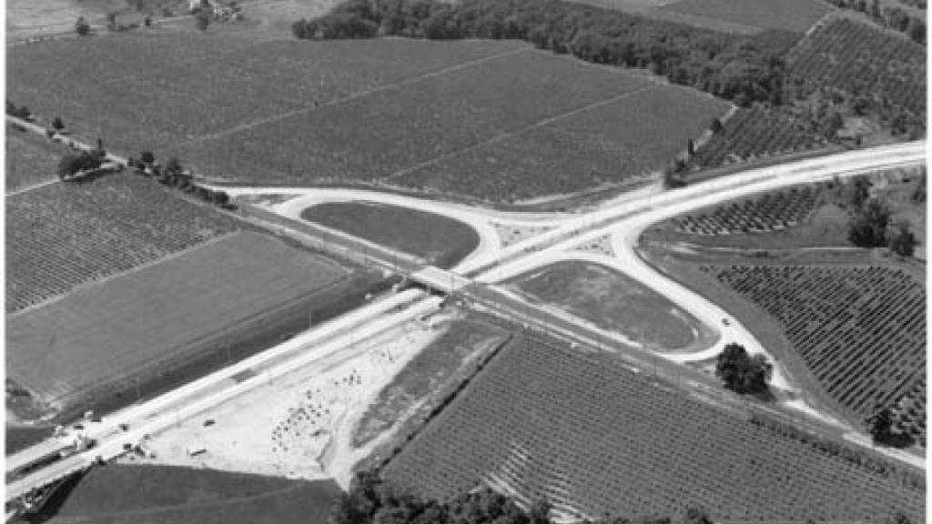
It’s important to remember that Canada never had a planned national highway system the way the United States did. Instead, the Canadian national government left such matters to the individual provinces to come up with and design their own highway networks. Being the most populated province, it obviously made the most sense for Ontario to come up with a high-speed limited-access network of expressways. What many people may not realize, however, is tha Canada was, in many ways, at the global forefront of highway development. Sean Marshall has a great article, “How Ontario Helped Invent the Modern Highway” to illustrate this example. A photo from that article:
The above picture is of a “cloverleaf” design interchange of the Queen Elizabeth Way (QEW). All the more impressive when you realize that this photo is from 1940! As Marshall points out, however, it would be very wrong to think that one could drive on a modern freeway from Niagara Falls to Toronto in the early days of World War 2. When the first section of the QEW was completed in 1937, most intersections along the highway still made use of stop signs and traffic lights. It wouldn’t be until the 1970s when the entire length of the QEW was at long last upgraded to freeway standards.
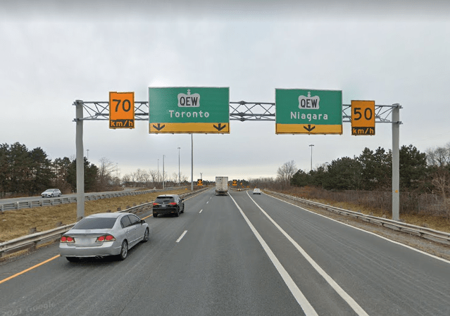
To this day, the QEW has one characteristic that sets it apart from every other modern freeway in North America: its absence of directional signage. That’s right: there are no markers for “north”, “south”, “east,” or “west” at intersections for the highway — rather, the cities are listed in place of the directions instead:
Northbound on Ontario Highway 406, near the QEW. No “east” or “west” on the signs here — just “Toronto” and “Niagara”
It’s easy for many of us on the U.S. side to forget that much of Canada is sparsely inhabited, and the northern topography of the Canadian countryside can make highway construction extremely daunting. The well-known Trans-Canada Highway, which was never assigned a national number, is practically built to expressway standards in parts of Ontario, but is an undivided meandering two-lane road in some of the other provinces. Some Canadians even argue that it’s often faster to travel from Vancouver to Toronto by entering the United States and driving I-90 and or I-94 to the 401 rather than use the Trans-Canada.
The province of Ontario has an extensive road system hierarchy. At the top of the list are the provincial highways, with the three-digit 400-series all built to modern freeway standards. The QEW is part of this system, with its designation as Highway 451, even though it is not posted on any signs. Below the 400 series are the “King’s Highways”, which are numbered from 2 to 148. Some of the King’s Highways are only 1 kilometer in length (0.6 miles), while Highway 17, which is Ontario’s section of the Trans-Canada, runs from the western border with Manitoba out to the eastern end of the province at 1964 kilometers (1224 miles).
After the King’s Highways, there is the 500 and 600-series, or the secondary highways. Then there is the 800-series, or tertiary highways. And then there is the 7000-series of highways, which tend to be unmarked. These four classes make up Ontario’s provincial highway system. Working down from the provincial level of the government, there are also the county roads, regional roads, municipal roads, district roads, and county highways.
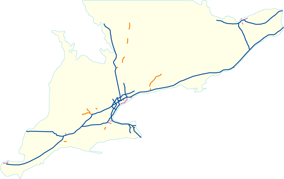
The following map shows the freeways that existed in Ontario as of circa 2015:
If you’re a little puzzled by this, remember: the blue lines are part of the 400-series highways, the purple lines are provincial expressways that are not part of the 400-series, and the orange lines are municipal expressways. Confused already? There are more expressways that are still in the planning stages, AND there are others that were not built at all, or at least not to completion. Our Canadian brothers and sisters sometimes do things on a different timetable than us Americans do, and we will explore that in a little more detail in upcoming posts.
Edit: It has been a *long* time since my last post. Due to recurring work and family issues, it’s been challenging to find time to write. Hopefully things are a little more settled now, and I look forward to posting in a more timely manner!
Travelling back up I-71 through Cleveland, and then along Lake Erie on I-90, we arrive on the eastern end of the “Rust Belt” of the United States: snowy Buffalo, New York. Of course, native Buffalonians are likely tired of hearing the only associations with their city being “snow” and “Rust Belt”. Aren’t there more positive things we can say about their city? There sure are! Buffalo actually has a rich history of achievements among the major U.S. cities: it is home to one of the first skyscrapers built in the world, the Guaranty Building. In 1886 it became the first U.S. city with electrically-lit streets. After Chicago, Buffalo is the city with the most houses built by architect Frank Lloyd Wright. Buffalo is also the hometown of five professional sports teams and two U.S. presidents. The city is also renowned for its extensive city park system and lively arts scene. Many other interesting facts about Buffalo can be found here.
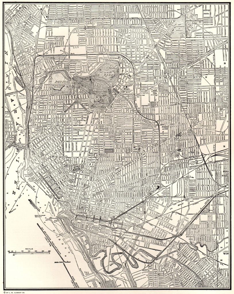
Buffalo’s road network also makes it unique from other cities: it is only one of three major U.S. cities (the others being Washington, D.C. and Boston, Massachusetts) with a “radial grid” street pattern, consisting of arterial roads branching out in many directions from its downtown area.
1940 City Street Map of Buffalo
According to Steve Cichon at BuffaloStories.org, Buffalo was considered to be “late out of the gate” compared to other major U.S. cities in its post-World War II highway planning, and so city planners were determined to make up for lost time by “pushing hard” and “pushing fast” to get construction of its expressway network underway. This did not sit well with some Buffalo residents. While some Buffalonians pressed for the necessity of connecting the downtown with Niagara Falls, the airport, and outlying suburban areas, other natives were far less enthusiastic, especially those who stood in the path of the wrecking ball in the city’s high-density inner neighborhoods.
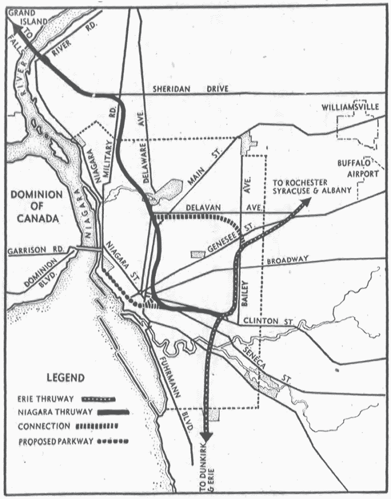
The 1946 plan for Buffalo was fairly simple. The proposal consisted of the Erie and Niagara Thruways (later I-90 and I-190, respectively) with some alterations from their current routing. Two connector highways were proposed, one linking the Erie and Niagara Thruways with a route that ran alongside Delavan and Bailey Avenues, and the other connecting the Niagara with the Peace Bridge to Canada.
1946 Buffalo Freeway Plan
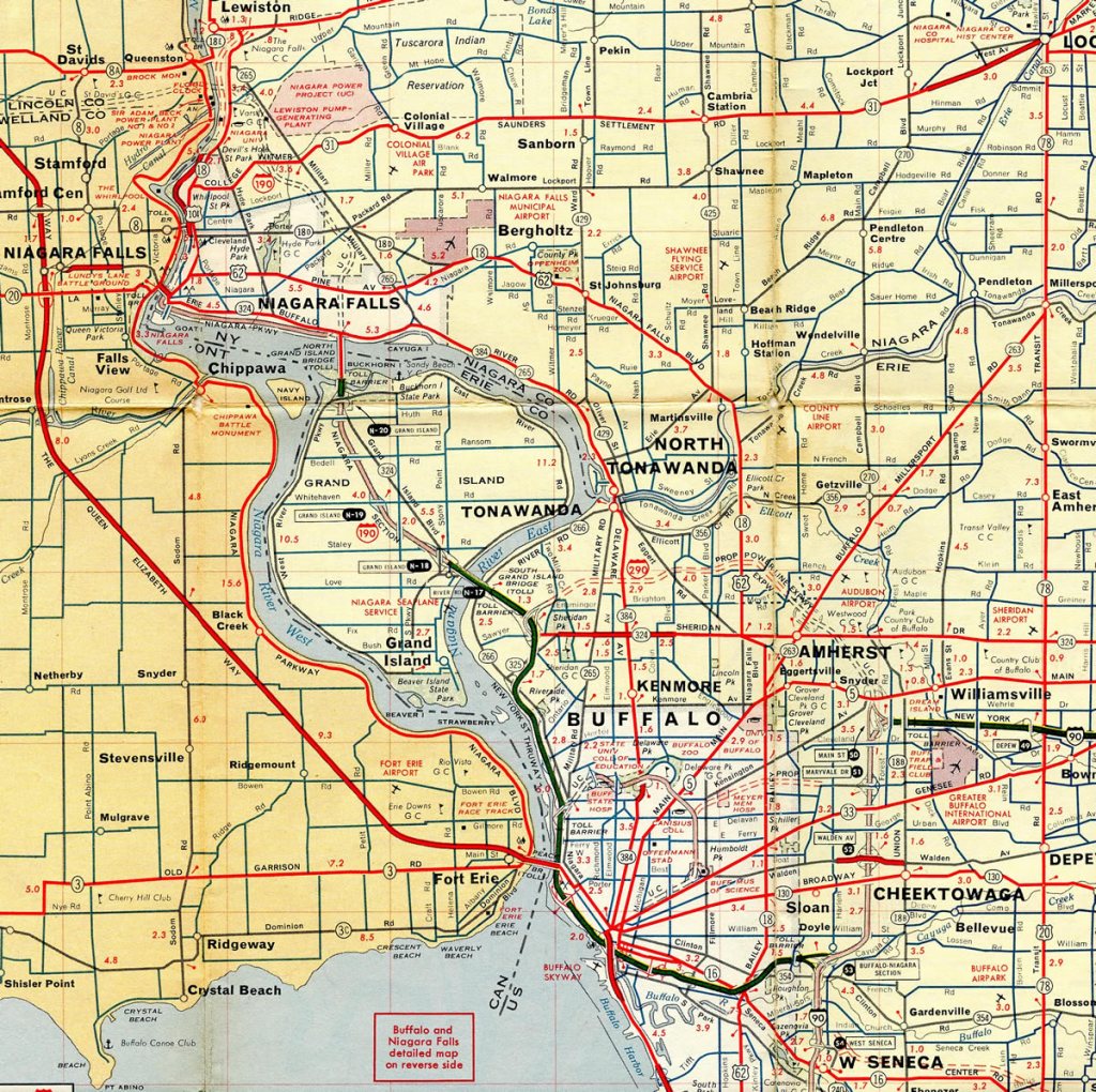
Of course, many changes were made in the following years, and by the early 1960s the planned expressway system already began to resemble what Buffalonians would recognize today:
Map of Buffalo, circa 1961. By this point I-90 and the part of I-190 up through Buffalo and Grand Island had been finished. A few years later, I-290, the Scajaquada, and (most of) the Kensington expressways would be completed as well.
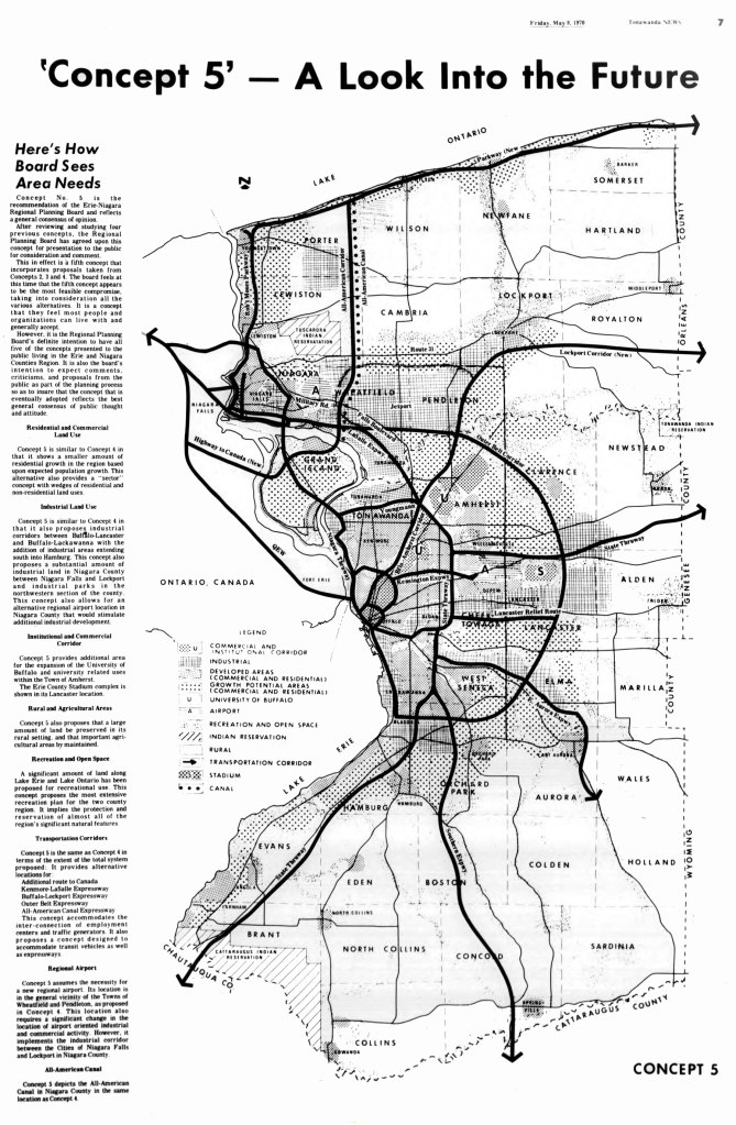
Of course, this doesn’t tell the whole story. Throughout the 1950s and 1960s, plans were already being considered to make Buffalo’s freeway system bigger, and in some cases, much bigger. By 1970, city planners in Buffalo drew up a regional transportation plan known as “Concept 5”, which, in retrospect, proved to be highly ambitious for the time. Right before the U.S. manufacturing sector took a major hit during the 1970s, local officials in Buffalo were anticipating a substantial boom in population for the metropolitan area, which would necessitate a major expansion in the metro area’s highway network. In much the same way as its city streets had been built, the plan for this revised “Concept 5” expressway system also (loosely) followed a radial grid pattern, with several concentric “loop expressways” connected by arterials spreading across the region in multiple directions.
Some of these mapped expressways were never built. Others were built years later, some to more completion than others, as you can see from this metro area map, circa 2015:
While there isn’t enough time to go into great detail on all of these projects, here are some of the more notable and controversial ones:
I-190:
While the actual construction of I-190 itself was never “canceled”, one other important aspect of the highway was. For many years, I-190 had the unique distinction of being something unusual among American highways: an urban interstate that was also a toll road. Most major cities in the United States have toll roads that go around or bypass major cities: think I-294 in Chicago or the newer Sam Houston Toll Road in Houston, Texas.
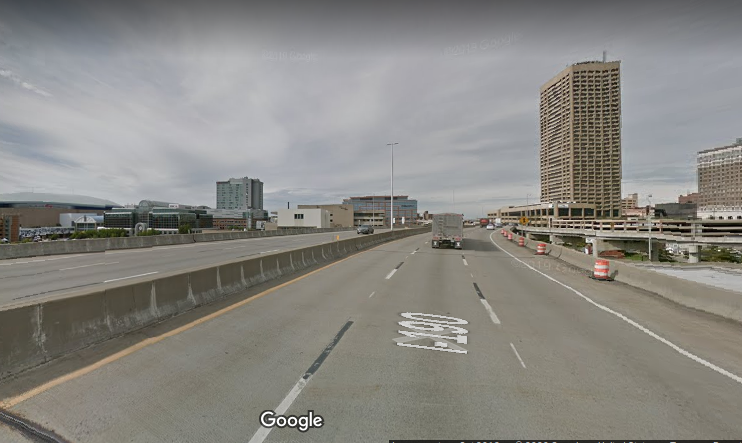
I-190, however, charges straight into the city of Buffalo from its northern terminus at the Canadian border before re-uniting with I-90 south of the city, with some picturesque views of the Buffalo skyline and the Niagara River along the way. Some Buffalonians have been critical of the current routing of the interstate, pointing out that the highway cuts off the downtown from the waterfront, a criticism we’ve seen already play out in other cities.
Northbound on I-190, near downtown Buffalo.
For over 40 years, I-190 was originally considered part of the New York State Thruway system. Originally the plan was for I-190 to become completely toll-free in 1996, after the bonds for the construction of the expressway had been paid off — but the tolls continued to be collected for another ten years afterwards. Eventually, 20,000 residents in the metro area banded together to sign a petition to do away with the collection of tolls altogether, pointing out that I-190 was the only interstate in upstate New York to levy tolls on local commuters. In late 2006, the collection of tolls ceased, along with the removal of the ubiquitous “blue hut” toll booths. Interestingly enough, the toll booths became a sought-after item in aftermarket sales after their removal.
One of the old I-190 Toll Booths
Scajaquada Creek Expressway (State Route 198):
The Scajaquada (prounounced “Ska-JACK-quah-duh”) forms the northern part of Buffalo’s “inner belt” freeway. A series of serious accidents in recent years led to the state government lowering the speed limit along the expressway from 55 mph to 30 mph in 2015. At issue is the fact that the Scajaquada curves in many places as it travels through urban park areas, oftentimes without substantial guardrails and/or concrete barriers, thus posing dangers to pedestrians, cyclists, and motorists alike. While some motorists routinely disregard the lowered speed limit, other Buffalonians have called for de-commissioning the expressway entirely, pointing out that the highway cuts Delaware Park in half.
Along the Scajaquada Expressway in Delaware Park
Kensington Expressway (aka “The 33”):
The Kensington forms the southern part of the “inner belt” freeway, although it doesn’t quite “close the loop” with I-190 at its southern terminus, ending instead in the middle of downtown Buffalo.
At the southern terminus of the Kensington expressway, near Elm and Tupper Streets.
For years, there were at least two proposals considered to connect the Kensington to I-190. One would have been at I-190’s Exit 8 interchange (Niagara St./State Route 266), although an equally likely candidate would have been the Exit 6 interchange (Canalside/Elm St.), which would explain the long extended entrance/exit ramps from I-190.
The Kensington also saw its share of controversies in its construction, having cut through Buffalo’s historical working-class “ethnic” neighborhoods and decimating the original tree-lined Humboldt Parkway. Along with the Scajaquada, calls have been made to remove and decommission the Kensington as well.
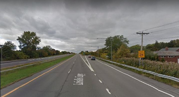
LaSalle Expressway:
The LaSalle is a 2 1/2 mile expressway that connects I-190 to Williams Road (SR 265 & SR 384) in the Niagara Falls area. Curiously, the LaSalle was never assigned an Interstate, U.S. Highway, or State Route number, and thus remains unnumbered. It originally was planned to extend further east as part of the “outer belt” Belt Expressway and further west to the Rainbow Bridge.
The LaSalle Expressway in the Niagara Falls area
Mile Strip Expressway:
The part of State Route 179 south of Buffalo between State Route 5 and U.S. Highway 62. At just over a mile in length, it is the only other part of the “outer belt” freeway that was completed during the 1960s.
Westbound on the Mile Strip, near State Route 5.
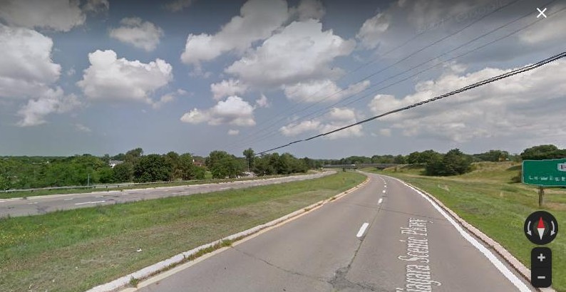
Niagara Scenic Parkway:
Originally known as the Robert Moses State Parkway until 2016. Plans were discussed in the late 1950s for a limited-access highway connecting the Rainbow Bridge in downtown Niagara Falls and heading north, eventually reaching the Lake Ontario State Parkway. The portion that ran through Niagara Falls State Park was largely removed during the 1980s, thus splitting the highway into two segments and rendering it discontinuous. Additional downgrading of segments of the parkway have continued in the years since. In early 2019, an additional segment was removed from Main Street (State Route 104) up to Findlay Drive, and to be replaced with pedestrian and bicycle paths. Will the rest of the parkway be downgraded or removed? It remains to be seen…
Northbound on the Niagara Scenic Parkway, near Lewiston.
I-990:
The only part of the Lockport Expressway that was completed. I-990 is the highest-numbered interstate in the United States, and also one of the later-built interstates. Construction did not begin until the early 1980s and was finished in 1990. There is still some question as to whether there will be any further extension of the freeway in the direction of Lockport.
Northbound on I-990, near the SUNY Buffalo North Campus Interchange.
Of course, I probably haven’t done much more than “scratch the surface” with what I’ve already posted. Buffalo has already written many chapters in its highway history, and will no doubt be writing more in its future.
Just a cautionary tale for all you budding writers out there: I would strongly recommend that when you do your writing, DO NOT do your composing directly online. My most recent post that I was working on was somehow deleted without my doing anything. The title was there, but all writing and pictures….gone. Nothing in the trash either. Apparently when WordPress says your most recent draft is “saved”, it does not mean it’s stored on a secure server somewhere ready to be restored if something happens. So, on that note…make frequent backups, and do your writing on a local program on your local computer, and THEN upload it to WordPress when you’re done. Hard lesson learned.
Edit: Well, it turns out I was wrong. Very, very wrong, thankfully. WordPress actually does keep old drafts of your posts. If any one you have the same problem, check out this discussion in the WP forums: “Help!? Draft Post Disappeared!” O me of little faith! The lost post was found! Still, I would encourage everyone to do what I haven’t been doing: backup early and often!
Look for the next (now-recovered) post in the next week or so.
Reader David, a Cincinnati native, had this to share in response to my last post:
“Haha, I was looking at your article again and I saw that you referred to Cleves Warsaw as Cleves Warsaw Pike. You can tell I am old because I never once knew it was Cleves Warsaw Pike. One of my best friends lived along Cleves Warsaw Pike and I always called it Cleves Warsaw Road (as it is a county road and almost all county roads in Hamilton County Ohio are Road, except for former State / US Routes such as Harrison Ave / Pike). Street name signs along county roads in Hamilton County do not include Pike / Road etc. So, I always assumed it was Road.
The west side of Cincinnati is so terribly interesting because it has so many abandoned roads. Why are they abandoned? Land subsidence. The most tragic tale of land subsidence has to be Devils Backbone Road. It’s such a cool name, but why is it called Devil’s Backbone Road? There’s no crazy curve on this road! Well, there was. It slid into Muddy Creek. That’s why Devils Backbone Road is discontinuous. It’s also why Muddy Creek Road is discontinuous near Devils Backbone Road. At least the hairpin turn on Ebenezer Road still exists! I just hate that they got rid of the old hairpin road sign (https://goo.gl/maps/LtHNYGaheQKZ3SPg6) and replaced it with a standard hairpin road sign. So sad. God, I wish these abandoned roads still existed. I love hills and curves. It makes driving more fun.
Another fun fact I learned in college is the history of Delhi Avenue. It is an avenue but mysteriously ends at Bender Road. Well, it didn’t used to. It used to go down the hill to Hillside Avenue. Technically, it still does. If you go to a winter aerial, you’ll see the old road down the hill still exists, but it is closed off. Before they abandoned the road, the Hamilton County Engineer had sections of Delhi Avenue on the hill that had eight feet of pavement due to subsidence. I wish I remembered if I learned this in Geotechnical Class or Risk and Reliability Class. (probably the latter).
I am a huge fan of historical roads and routes, I have always found them fascinating in every city I have lived in. I just happen to know historical roads in western Hamilton County Ohio the best.
Also, if you can’t tell I am a west sider. Oh how I miss home.
Keep up the good work!”
Sometimes your best and most interesting information comes from those who read your site. Thanks, David!
Devising a comprehensive transportation system for a city like Cincinnati, Ohio is no easy feat. As you can infer from the title, the city is home to seven major hills within the city limits, with some local experts arguing that there are considerably more than that. And as anyone with a smidgen of highway planning and/or construction will tell you, building roads with hills or mountains in the vicinity can be way more costly and complex than building on flat land, not to mention the increased safety issues. Complicating matters is the fact that the Cincinnati metro area overlaps with the state of Kentucky, so major transportation projects that benefit the area as a whole can require multiple levels of government involvement. Further complicating matters is that much of the city, including the downtown business district, sits atop the Ohio River, which has been prone to major flooding throughout the city’s history. One particular devastating flood occurred in early 1937, which left 100,000 residents of Cincinnati homeless. As a result of these factors, Cincinnati’s transportation system is probably far more complicated, convoluted, and fascinating compared to many other cities in the United States. Along with the many roads and freeways, whole networks of bridges, tunnels, and viaducts link the city’s challenging topography.
Cincinnati has had more than its share of “false starts” in its transportation history. For fans of “abandoned Ohio”, the unfinished Cincinnati subway system is an exciting focal point. Originally planned to connect downtown with the suburb of Norwood, construction on the line began but was then halted in the 1920s. Since then the six stations have been sealed off from view from the general public, though they are still very much in existence.
Underground view of the Race Street Station. Photo taken from Cincinnati-transit.net.
Then there’s the issue of air travel. Cincinnati’s main international airport is not in the same county or even the same state, but across the river in Covington, Kentucky, hence the airport’s three-letter code “CVG”. Until the 1940s, Lunken Airport, which was located on the city’s east side, was the main commercial flight operation. That is, until the 1937 flood submerged the airport under 20 feet of water. Even if the flood didn’t happen, the airport was constrained by foggy conditions and the surrounding hillside — in other words, no room for expansion. Originally there were plans to build a new airport in the suburb of Blue Ash, but voters there rejected the idea. Shrewd political leaders in the nearby flatlands of Boone County, Kentucky, however, were able to successfully lobby for the new airport, which opened for business in 1946.
And then, of course, there are the freeways. Along with the fabled “seven hills”, Cincinnati has seven freeways running through its metro area as well: I-75, I-71, I-74, I-275, I-471, State Route 126, and State Route 562.
Perhaps the most daunting aspect of Cincinnati’s highway system is the issue of safety, or lack thereof. Journalist Erin Caproni points out that of the 350 most dangerous crash sites in the state of Ohio, over 50 of them are in the Cincinnati area alone. Particularly problematic intersections include State Route 126 and I-71, Pfeiffer Road and I-71, and I-471 and I-71. As if I-71 didn’t have enough problems in Cincinnati, local critics have also disliked the fact that the freeway cuts right through the central business district between Second and Third Streets in the downtown area, limiting pedestrian access to the riverfront.
Other freeways in Cincinnati have their own sets of issues. Looking at local road maps, one can see that the major bypass, I-275, looks like a misshapen pinto bean. From a purely logical perspective, however, I-275 is arguably not a particularly efficient bypass around the city. Traveling north from Kentucky, one can take the western part of the bypass, which travels through the Kentucky suburbs, then wanders over into the state of Indiana before reaching Ohio, slowly meandering back to I-75 after 43 miles. Taking the eastern route isn’t much shorter, at 41 miles.
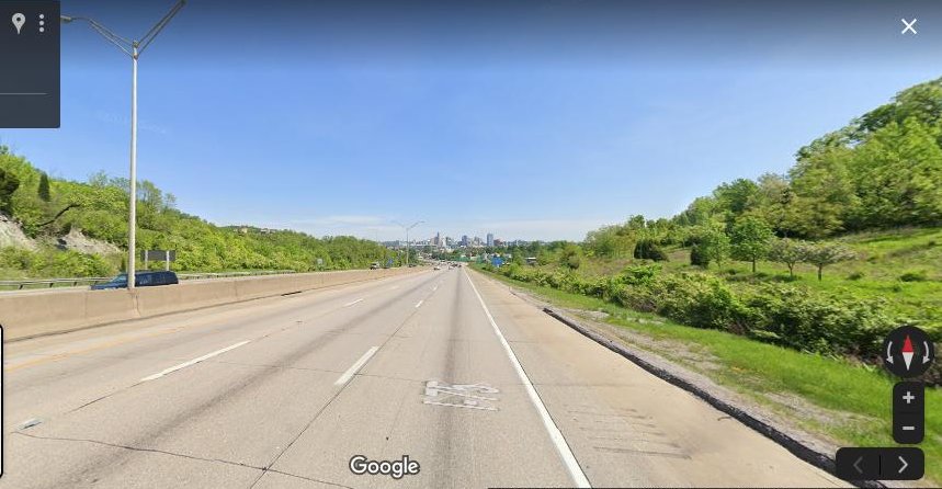
Of course, if one doesn’t want to take the long journey of I-275, one can brave I-75 through the metro area itself, which in various parts is more like a roller coaster for motor vehicles. One particularly infamous area, known as “Death Hill”, is a long downhill stretch of the freeway between Kyles Lane and the Brent Spence Bridge in Covington. Known for its very high levels of accidents and fatalities, this segment of I-75 opened in 1962, though some might find it hard to believe that it would meet modern highway safety standards today.
Facing northbound on the long downhill slope of I-75 in Covington. Downtown Cincinnati is in the distant center background.
Then there’s State Route 126, otherwise known as the Ronald Reagan Cross-County Highway. The Cross County has proven to be a political lightning rod for the Cincinnati area. Originally conceived as a means to improve east-west travel in central Hamilton County, developers wanted to build the freeway as a means to relieve congestion on nearby Galbraith Road. By the early 1960s, the first segment of the Cross County was complete, linking Galbraith with Montgomery Road, just to the east of I-71. By the mid-1970s, another segment was completed between the west side of I-275 and Colerain Avenue. It would be a whole 20 years before the two segments were finally linked together in 1997. Even then, the Cross County remains incomplete to this day. Residents of Indian Hill and Crosby Township successfully blocked the remaining segment from being completed, which would have connected Montgomery with the eastern side of I-275.
At the eastern terminus of the Ronald Reagan Cross County Highway, near Montgomery Road.
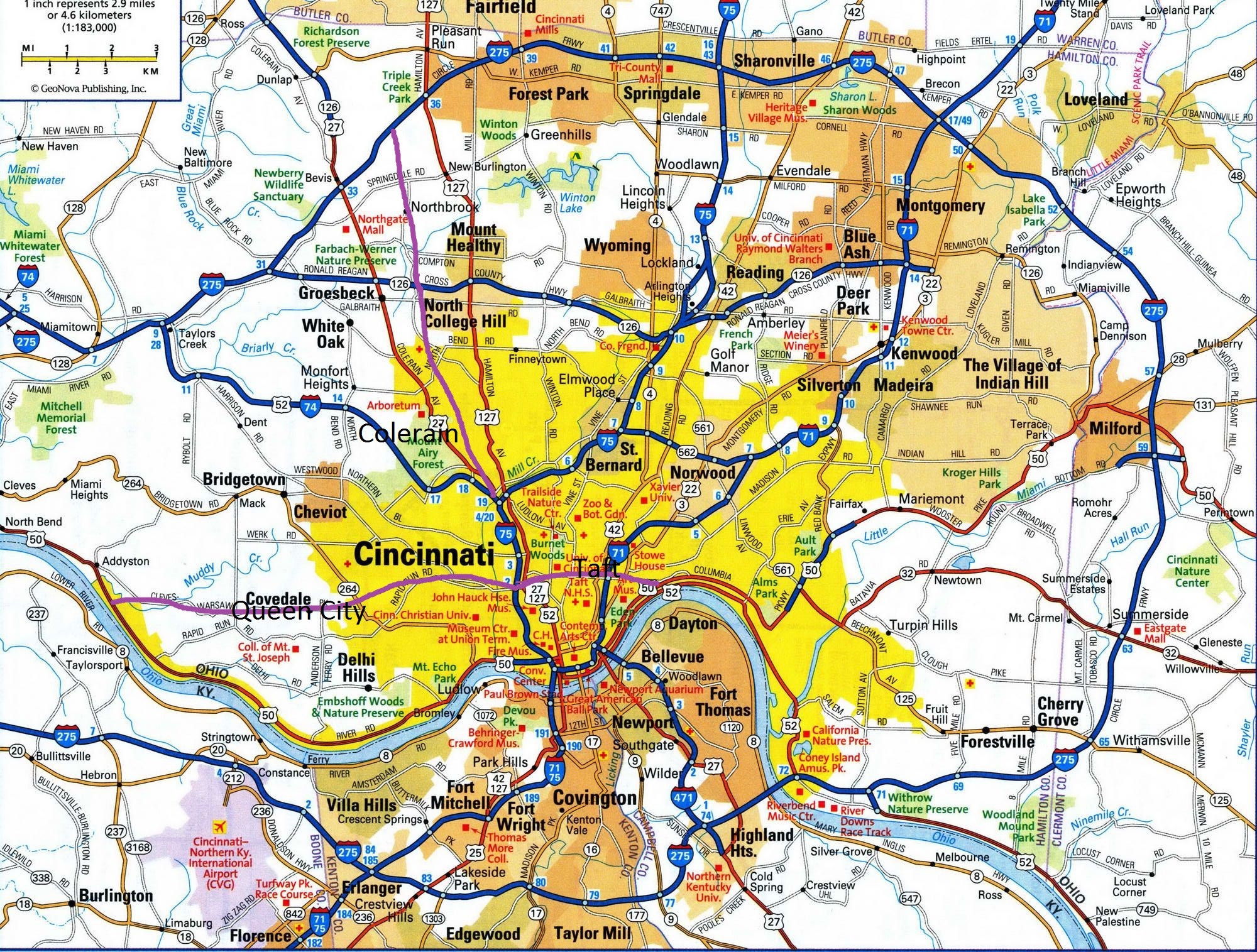
The Cross County was not the only expressway to fail to see completion in Cincinnati. Just as local historians point out the existence of more than seven hills, so too were there more than the seven aforementioned freeways. Three in particular hardly made it beyond the planning stages: the Colerain, the Taft, and Queen City freeways were all scrapped in their early stages.
Finding information on these scrapped freeways online isn’t easy, but reader David, a Cincinnati native, kindly sent me some relevant links. According to the website Cincinnati-transit.net, the Taft expressway was to have run along nearby William Howard Taft Road, with its western terminus at the I-75/Western Viaduct/Harrison Ave. interchange (Exit 2B), and its eastern terminus at Columbia Parkway (U.S. 50), most likely near Torrence Parkway, with additional interchanges at Ravine Street, Vine Street , I-71, Gilbert Avenue, Victory Parkway, and Woodburn Avenue.
Map of the proposed Taft freeway showing some of the proposed interchanges, including Vine Street and I-71.
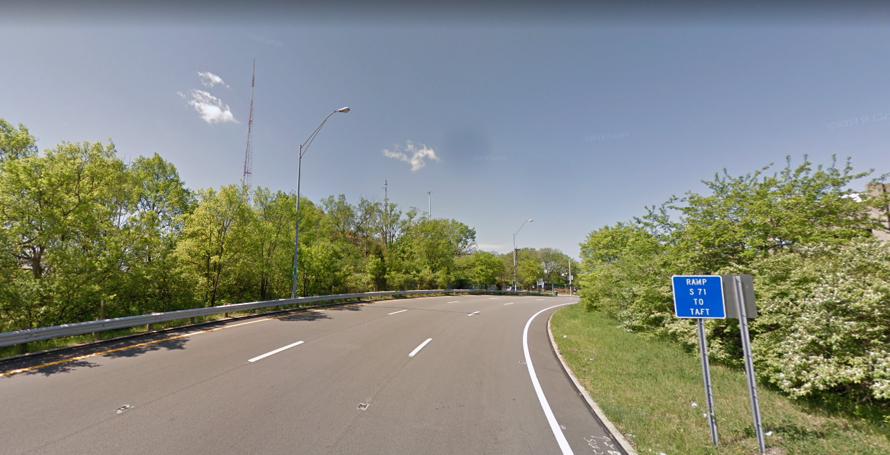
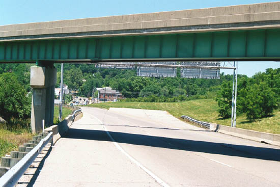
Although there isn’t a whole lot of physical evidence to support the planned construction of the Taft, one tantalizing piece is the I-71/Taft Rd. interchange (Exit 3A). The off-ramp on southbound I-71 is exceptionally long, and then widens to three lanes before reaching the first stoplight:
The Queen City expressway would have begun on the opposite side of the I-75/Western Viaduct interchange, traveling west and presumably running near Queen City Avenue and Cleves Warsaw Pike. Proposed exits would have included Grand Avenue, Quebec Road, Queen City Avenue, Glenway Avenue, and Anderson Ferry Road.
Facing west on the Western Hills Viaduct, near I-75. This would have been the eastern terminus for the Queen City Freeway.
Finally, there was the proposed Colerain Expressway, which would have connected I-74 at the Colerain Avenue (U.S. 27) interchange with I-275 between Colerain and Hamilton Avenues, with interchanges at Compton Road, Galbraith Road, and North Bend Road.
Looking northwest at the Colerain/I-74 interchange. Note the ramp stubs for the proposed Colerain freeway. Photo courtesy of Cincinnati-transit.net.
The following map would give you some sense of where all the freeways would have been located, lined in purple:
Well, that’s enough for our “Ohio Tour” for now. Next, we will head out east to Pennsylvania and upstate New York. Plenty more to discover there!
Has it really been a year since I posted to this site? Well, sometimes life has a habit of getting in the way of your other plans, and there’s a lot that I, and most likely all of you, have been dealing with over the last year. Look for new posts starting next month! We’ll explore more altered and/or canceled highways, including ones in Boston, Atlanta, St. Louis, Seattle, Toronto, and many more! May you all continue to be safe and stay healthy!
Resuming from a long break, we continue down I-75, arriving in Dayton, Ohio, which is best-known for the Wright Brothers, who would pioneer a whole new mode of transportation for the 20th and 21st century. Dayton proved to be no slouch either when it came to ground transportation, either. According to Wikipedia, Dayton’s downtown road system is unlike most other Midwestern cities its size: the streets are very broad, with two to three lanes running in each direction, with ample space for pedestrians and cyclists.
View of South Main Street in downtown Dayton.
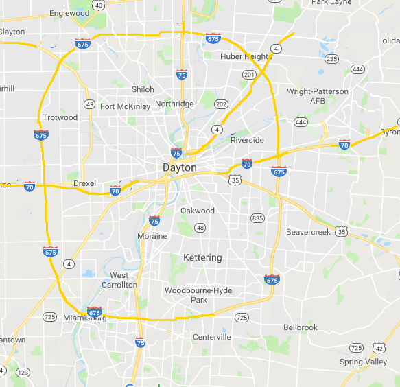
Dayton’s freeway system is also unlike its neighboring cities of Columbus, Cincinnati, and Indianapolis. From a strictly logical standpoint, Dayton’s freeway network might have made more sense if it had been built like this:
Instead of looking like what it ended up with:
As you can see from the above map, Interstate 70, one of the longest east-west highways in the United States, misses the city of Dayton entirely, traversing its northern suburbs instead. This might not have been unintentional, since I-70 in Ohio was built to replace traffic along U.S. Highway 40.
What’s really odd about Dayton is that up until the mid-1990s, there were hardly any freeways in the western part of the metro area. Eastern Dayton, in contrast, had several expressways crossing its terrain, including U.S. Highway 35, Ohio State Route 4, and Ohio State Route 844 (a spur freeway that connects to Wright-Patterson Air Force Base), and I-675. I-675 appears as a somewhat malformed semi-circle, connecting I-75 south of Dayton with I-70 near Springfield.
It might be helpful at this point to explain the rationale of three-digit interstates in the United States and why they are numbered the way they are. As a general rule, three-digit interstate highways that begin with an odd number (like 1, 3, 5, and 7) are known as “spur” interstates — they connect the two-digit “parent” interstate with a city’s downtown or central business district (such as I-175, I-375, I-575, etc.) In contrast, three-digit interstates that begin with an even number (2, 4, 6, and 8) are usually “by-pass” or “loop” interstates — going around a city, usually to avoid potentially heavier traffic within the central business area (like I-275, I-475, etc,) and re-connecting with the “parent” two-digit interstate at both ends. Wikipedia has a helpful visual:
Not all three-digit interstates follow these rules, however, and I-675 in Dayton is one of them. Of course, there’s a story behind all of this. So what happened? First, let’s again go back to the planning stages that took place in the 1950s and 1960s. For this particular article, I have to give enormous credit to the author at Daytonology.com (http://daytonology.blogspot.com). Although his website has not been updated in a very long time, and at one point he even voiced his intention to take the site down, supportive fans and readers pleaded with him to leave it as it was, and because of that decision we still have access to a treasure trove of information about the Dayton area. Major credit is also due to user “Jeff” at the forums of urbanohio.com, who also has a wealth of old city maps in his posts.
Before World War 2, Dayton, along with many other cities in the United States, was pre-occupied with how to alleviate heavy traffic and congestion in its downtown area. Talk of creating a network of parkways was proposed as far back as the 1920s, but by the end of the war the discussion had shifted to building a network of higher-speed, limited-access freeways instead. As we’ve seen before in places like Winnipeg, extensive research was conducted to study the traffic patterns of the city, and where the construction of such highways would provide the most benefit.
As you can see from the above map, traffic was particularly heavy along U.S. Highway 25 and Ohio State Route 4. What gets interesting here is the debate Dayton had over where else freeways should be built. By the late 1950s the city had decided on a “hub and spoke” network, with multiple freeways radiating from the downtown area:
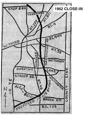
Not long after the above plan had been proposed, however, that calls were made for Dayton to have a proper by-pass expressway around the downtown, and by 1962 plans were in place for Interstate 675, which would have connected to I-75 in Miami Township at its southern terminus, and then re-connecting with I-75 in Northridge at its northern terminus:
What then followed over the coming years proved to be a series of messy politics, as the author of Daytonology points out in his series of articles. The original route for I-675 overlapped most of its length with the proposed Southeast Freeway. While the Ohio Department of Transportation signed off on its approval for the plan, the Bureau of Public Roads (a precursor to the Federal Highway Administration) would not, citing the proposed I-675 as a “parallel expressway” — as a result, Dayton was unable to secure federal funding for the project.
By 1965, the proposal for I-675 had evolved to its present day course, swinging to the eastern suburbs around Wright-Patterson Air Force Base and the newly-built Wright State University Campus. Real-estate speculators, it was believed, would also benefit from the altered route. But again, the federal government would only pay for 50 percent of the funding for the new highway — it was up to the state of Ohio and local governments to come up with the rest of the money. As a result, Dayton re-allocated funding that would have gone to freeway development on the western side of the metro area, and used it to complete I-675. Although I-675 was originally slated for completion in 1975, further delays and controversies resulted in the highway not being finished until 1989. The conflict reached a crescendo during 1979, when the Ohio Department of Transportation threatened to sue then-Transportation Secretary Neil Goldschmidt. Goldschmidt had agreed only to fund construction of I-675 only between I-70 and U.S. Route 35. The state government accused Goldschmidt of “a usurpation of the authority of local and state governments to determine the destiny of their highway system.” However, Thomas Downs, who was then a planner for the Federal Highway Administration, cautioned the city of Dayton and the state of Ohio against taking legal action against the Transportation Secretary, arguing that the courts had sided with the federal government numerous times over similar incidents.
“All politics is local,” as the saying goes. Maybe not, but Dayton’s long road with Interstate 675 is a prime example of how federal, state, and local politics collided with each other to make the United States highway system what it is today.
View of I-675 near Wright-Patterson AFB and Wright State University.
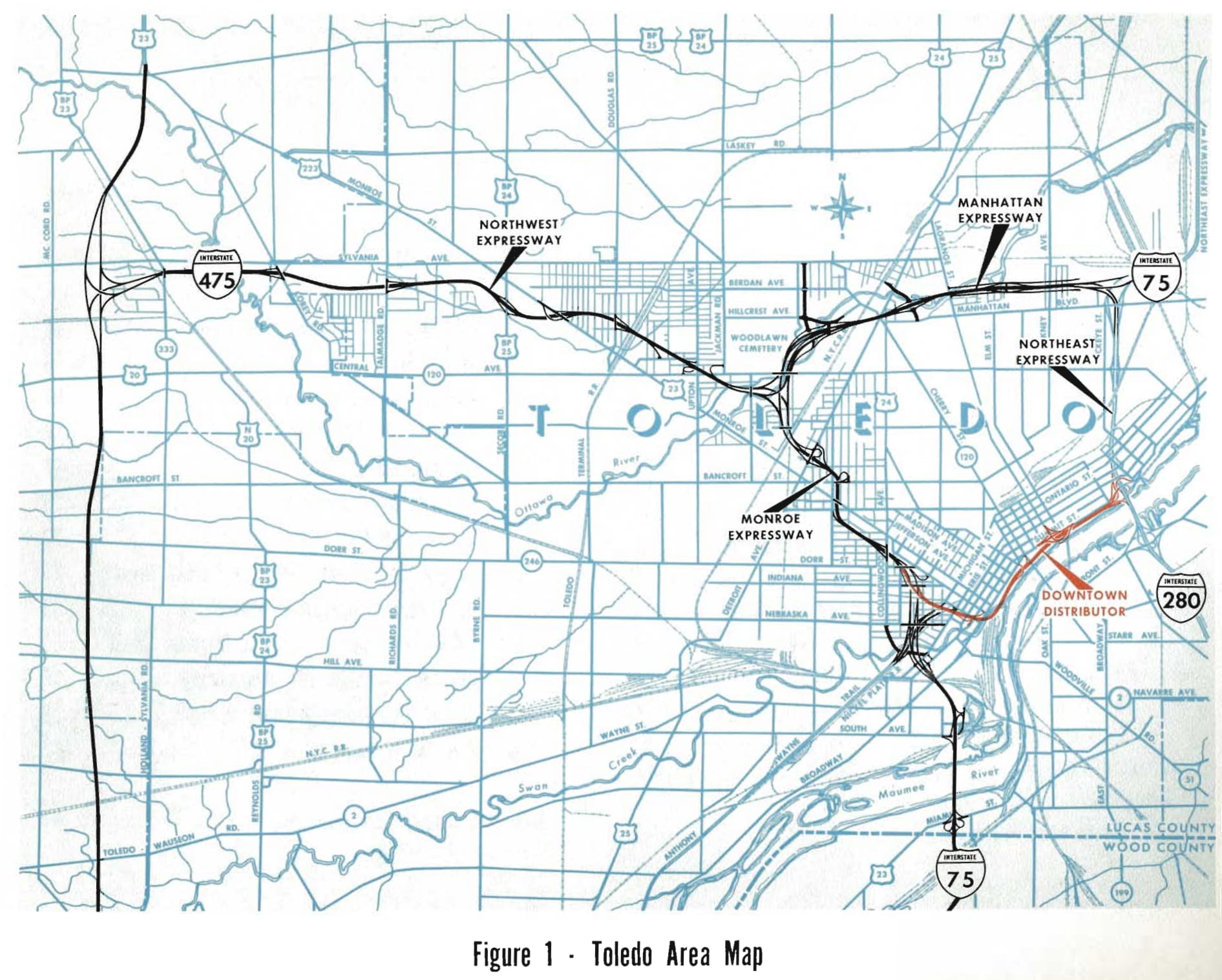
Traveling south on I-75 from Detroit, we arrive a mere 60 miles away in the Midwestern city of Toledo, Ohio, which also happens to be the native home town of yours truly. As a young person on the city’s west side, I remember feeling confused whenever I would look at maps of my neighborhood and see streets stop at the edge of Interstate 475, only to start up again on the other side of the expressway. Hadn’t anyone ever thought to build bridges when these streets were built? Of course, my memory only went back to about 1980 or so, and so I had to rely on my mother to help fill in the “missing history” that I didn’t know about. My mom, who also grew up on the west side, told me the story of how, in the late 1960s, certain houses were painted with large “X”es on their front side in her neighborhood — these were the homes that were to be marked for demolition to make room for the new freeway.
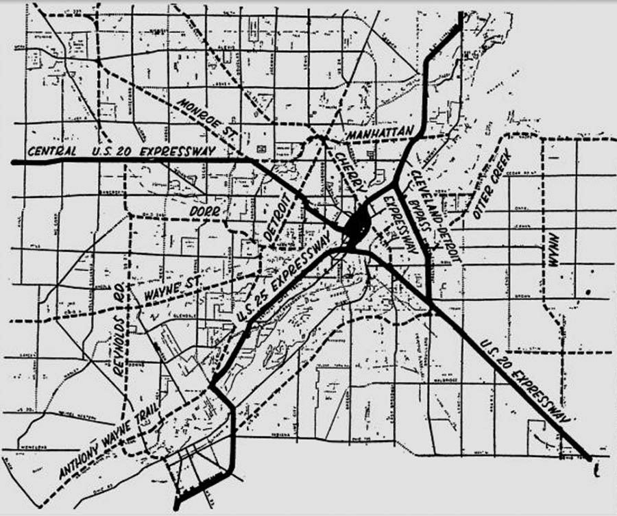
While the boom of freeway construction in Toledo happened during the 1960s and 1970s, like many other American cities, plans for the area had been in consideration for many years. Many thanks need to go to the author of Toledohistorybox.com for providing this info. (for you native Toledoans out there, be sure to check out his site! Lots of interesting history!) The 1949 freeway plans looked quite a bit different from what was ultimately built:
For those of you who are familiar with the Toledo area, you can see the U.S. 25 Expressway (later I-75), was originally planned to cross the Maumee River just east of downtown Perrysburg, travel along the Anthony Wayne Trail as it approached downtown, and then skirt north of downtown near the Buckeye Basin and Mulberry Park before turning north again towards Detroit. The U.S. 20 Expressway (later I-80 and I-90) was re-routed south when the Ohio Turnpike opened in 1955, though the western portion in the city limits would later be re-designated as I-475. The Cleveland Detroit Bypass (later I-280) was originally planned to run only from the area near Woodville Road to just north of downtown.
By the mid-1960s, plans had been altered to the point that the Toledo freeway system developed to its present day layout. One issue remained to be decided: how to get commuters in and out of downtown more efficiently. Rush-hour traffic would routinely jam the streets, and plans were discussed to build an additional expressway that would link I-75 with I-280 via downtown. Several routes were considered:
In 1964, the Toledo city council gave approval to construct the Downtown Distributor Freeway on the southernmost route, placing it along the Maumee River, with the designation of Ohio State Route 112.
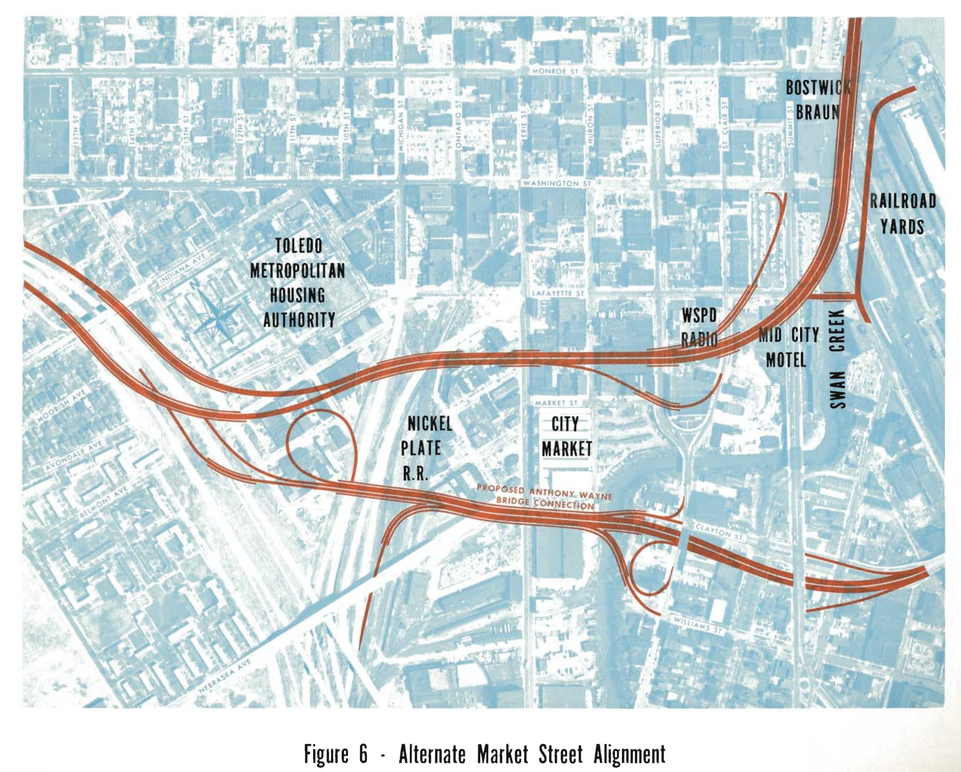
Plans were also discussed to add an additional spur to the Distributor, which would have allowed traffic on southbound I-75 to exit off directly on to the Anthony Wayne Bridge, thus providing easier access to the city’s east side:
An artistic rendering of the western portion of the Downtown Distributor Freeway, drawn up by the engineering firm Howard, Needles, Tammen, and Bergendoff. The freeway was planned to be elevated between the I-75/Washington St. Interchange and Summit Street before descending to ground level.
In 1970, the Toledo Blade followed up with an endorsement of the planned freeway in its editorial page, after commenting favorably on the newly opened I-475:
“What [I-475] will demonstrate…is the need to expedite the planning and construction of the first phase of the downtown distributor. This is the key link that will carry the heavy volume of traffic into the central business district…bogged down by indecision, changing plans, and disagreement over routes, this distributor is still a number of years away; meanwhile, thousands of drivers who will be using the expressway in the downtown area are simply going to have to move from and to it over narrow city streets that were never designed to handle the volume expected.”
Although there were still plans to construct the first phase of the Distributor (from I-75 to Summit Street) as late as 1972, discussion soon fell off the map. The Distributor would likely have had multiple environmental impacts on the downtown area, including the removal of multiple housing projects and commercial businesses in its path, which also would have led to increased financial costs for the city.
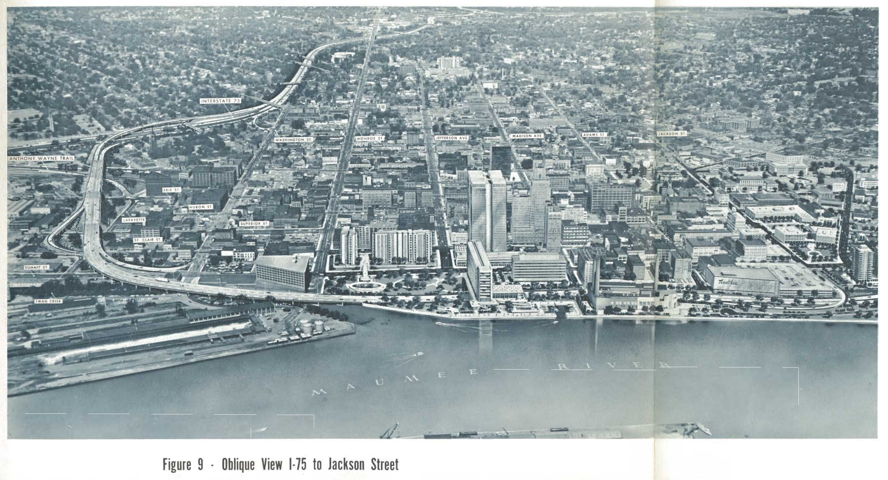
Today, there is little evidence remaining of the planned Downtown Distributor. The ramp stubs at I-75 at Washington Street, which would have marked the western end of the freeway, were apparently removed years ago. The eastern end of the freeway would have intersected at the I-280/Summit Street Interchange, which was removed in 2007 when the Veterans’ Glass City Skyway Bridge opened to traffic — the upside being a newly re-constructed I-280 that was considerably safer to travel on.
View of the re-built I-280/Veterans’ Glass City Skyway from Summit Street. The Craig Street Bridge, which carried traffic on the old I-280, is visible below the new bridge and is open to cyclists and pedestrians.
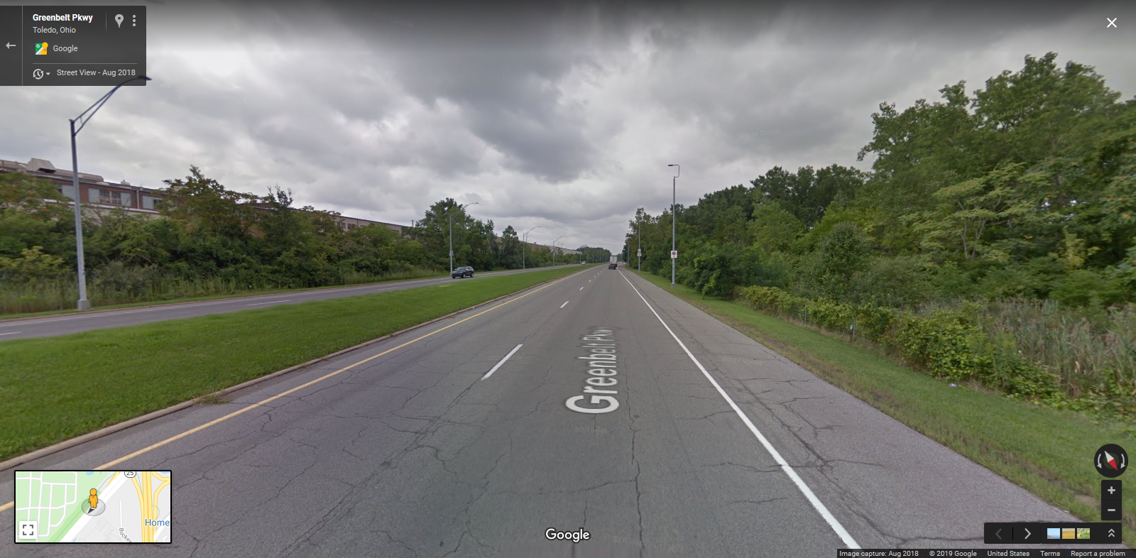
That might be the end of the story, but there is another interesting wrinkle: later on in the 1970s, plans were devised to construct the Buckeye Basin Greenbelt Parkway, which would replicate some of the functionality of the original Downtown Distributor. The original plan was for the parkway to connect downtown Toledo with the northeastern most area of the city, Point Place. Construction began in 1996. Political controversy over the potential of destroyed environmentally-sensitive wetland areas eventually put a halt to the Greenbelt Parkway as well, which currently ends at Galena Street, just east of I-280. As was the case with Detroit, even automobile-friendly cities like Toledo can decide that they’ve reached their limits when it comes to new highway construction.
Heading towards downtown Toledo on the Greenbelt Parkway, near Mulberry Park.
Traveling from the capital of the federal government to the capital of the automobile industry, we arrive at the largest U.S. city on the Canadian border. Detroit, Michigan has been known for its spectacular rise and fall throughout the 20th century. The “Motor City” was not only an enormous hub for the car industry, but also home to Motown, which launched the careers of many famous African-American musicians. Detroit is also home to many professionals sports teams (the Lions, Pistons, Tigers, and Red Wings) who each have their cohort of die-hard fans. Detroit is also a “melting pot” of many peoples from around the world, and there are a slew of ethnic restaurants bound to satisfy anyone’s taste (Chinese, Greek, Italian, Mexican, Middle Eastern, and Polish eateries abound).
Yet in spite of all these assets, Detroit struggled mightily during the latter half of the 20th century. The population declined from a peak of 1.86 million in 1950 to a little over 700,000 today. It’s no surprise that most major cities in the so-called “Rust Belt” saw major declines over the last 60 years, but Detroit was hit especially hard. If you ask people why Detroit has had such problems in recent decades, you are bound to find multiple answers: from automation in the automobile industry, to racial tensions and the urban riots of the 1960s, to corporate greed, to the decline of unions (or stranglehold of unions, depending on who you ask), to the accusations of corruption and incompetence of city governments over the years. The fallout from all these events have led to a particular bitterness and hostility between different sides in Detroit’s politics. Is there a way out? Possibly. Efforts are under way to revitalize the city, and perhaps there may come a day when Detroiters can overcome their differences and work together to get the Motor City back on its feet.
It should surprise no one that Detroit, being the hub of the nation’s auto industry, was way ahead of other cities when it came to planning high-speed motorways: the city can arguably claim to have built the first urban expressway in the United States. As a result, the Davison Freeway has had a longer history, with more twists and turns, than the other projects that have been covered so far on this site.
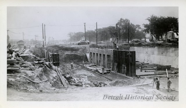
The story of the Davison starts way back in 1940. At that time, Davison Avenue was a busy corridor, shuttling commuters back and forth between Detroit and its northern suburb of Highland Park. Traffic had reached a point of gridlock, and in 1941 the Highland Park city council voted to rebuild the road as a freeway, and demolition commenced for over 130 homes located along the avenue. By the end of 1942, the freeway was completed and opened to traffic, with a total length of 7000 feet (about 1.25 miles long).
Demolition and widening of Davison Avenue during freeway construction.
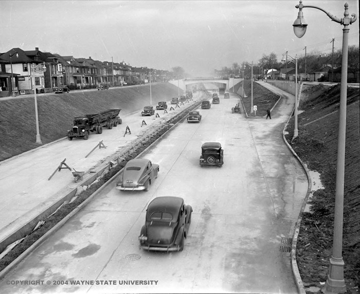
The Davison Freeway shortly after being opened to traffic.
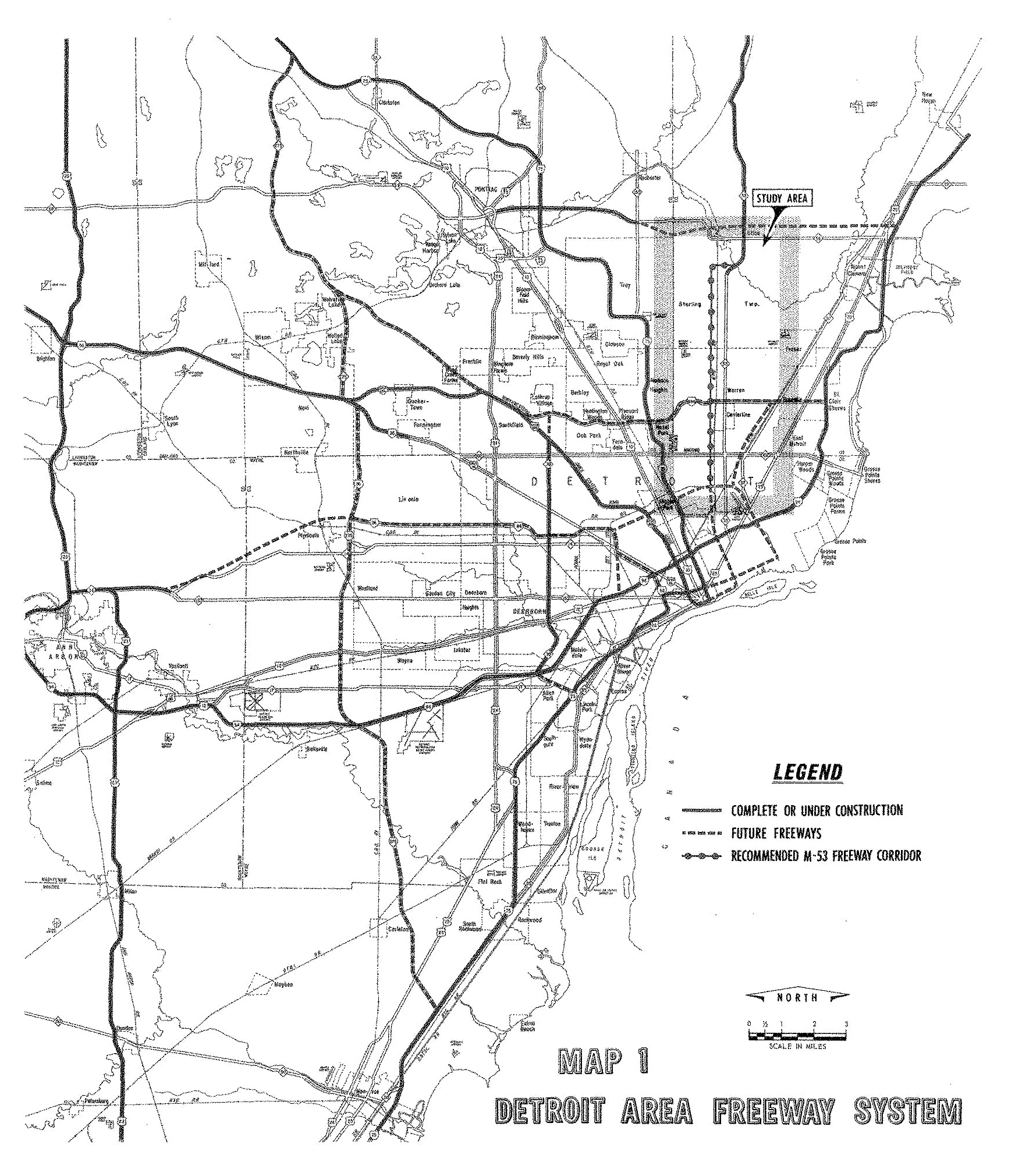
The Davison was only a drop in the bucket to what was planned for the city of Detroit. Even before the end of World War 2, Detroit already had plans on the board for multiple expressways to cross every section of the city.
As the 1940s and the 1950s passed, Detroit scaled back its freeway plans somewhat, and the layout started to resemble the network that is in place today:
As you can tell from the above maps, the Davison Freeway was only the start of what was to come. The Vernor and Conner Freeways were never built, and opposition to the proposed freeway along Grand River Avenue later caused I-96 to be re-routed along Schoolcraft instead. In 1957 the Davison Freeway was extended west to connect with the newly-opened Lodge Freeway (U.S. Highway 10), and in 1968 was extended east to Conant Street, also connecting with the I-75/Chrysler Freeway, which had just been finished. The Davison had now more than doubled in total length to 2.85 miles. Although plans for some of the other freeways in Detroit had been scrapped by the late 1960s, transportation planners were hoping to extend the Davison Freeway further west to meet up with I-96, as well as further east to Mound Road.
1967 Michigan DOT plans for the Detroit/Ann Arbor freeway system. Note the plans to extend the Davison further west and east, along with a greatly (!) extended M-53/Van Dyke Freeway that would have run to the edge of downtown Detroit.
As late as 1973, E.V. Erickson, who was the chairman of the State High Commission in Michigan, advocated for the extension of the Davison, along with 13 other freeways throughout the state. The proposed highways were to be built using funds from Governor William Milliken’s transportation package. However, local opposition to further freeway construction, which had been brewing for years, led Mayor Coleman Young and the Detroit City Council to ax the extension for the Davison.
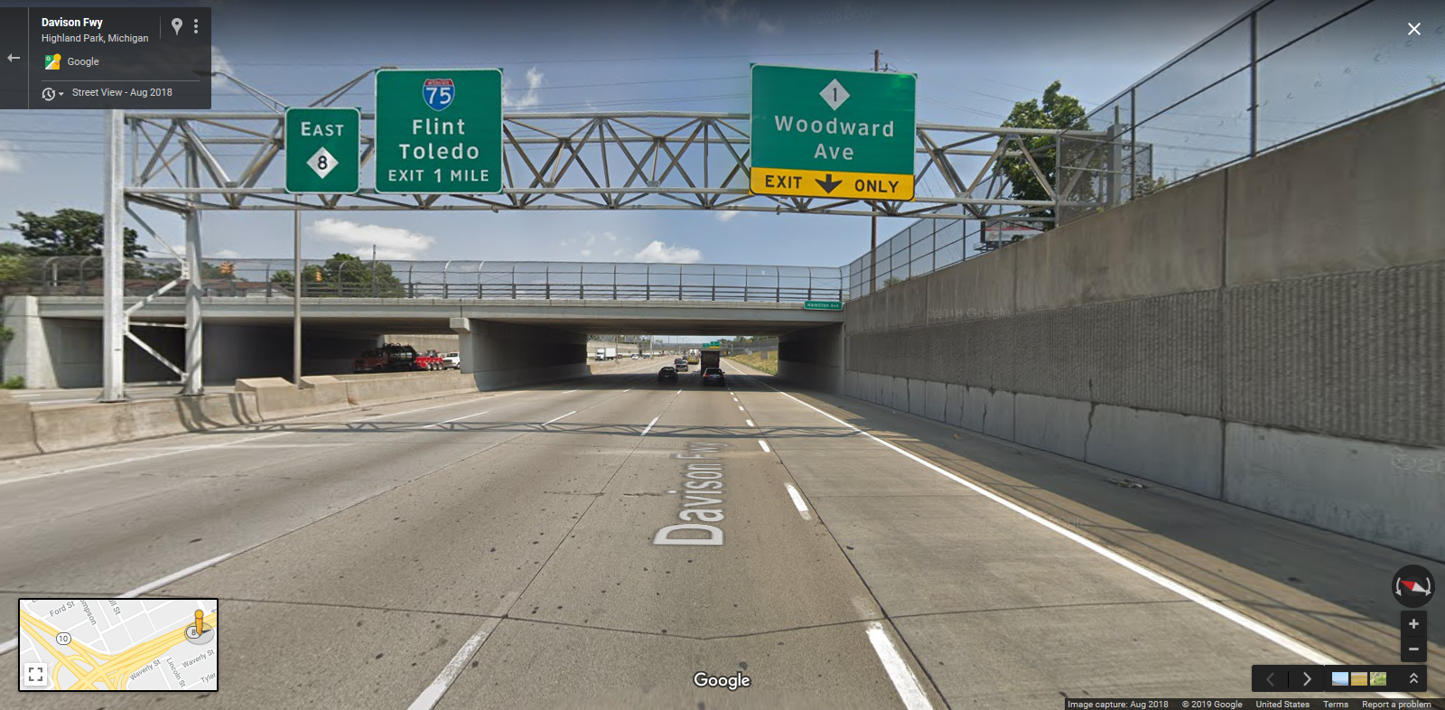
By the mid-1990s, questions arose as to what the fate of the Davison would be. The freeway was closed by that point, due to the antiquated and unsafe conditions of the road: high volume of traffic , no shoulders, narrow lanes and a narrow median had all conspired to make the Davison unable to meet modern safety rules and regulations. Incredibly the original concrete had held up well over its 50-year lifespan. What to do? There was some talk of filling in the depressed freeway and converting the Davison back into a city avenue, although, interestingly enough, there was significant opposition to this idea by residents of both Detroit and Highland Park. After some back-and-forth political tussling between Governor John Engler and local leaders, the Davison was renovated as a modern-day eight-lane freeway, with wider shoulders and a concrete barrier in the median. Maintenance of the highway was transferred from local to state control, and the Davison was thus designated as Michigan State Route 8. The re-constructed freeway was re-opened to traffic in 1997.
Facing eastward on the reconstructed Davison Freeway.
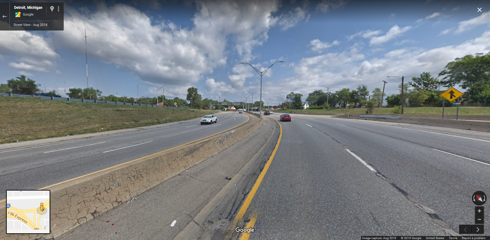
Facing east at the I-96/Davison Avenue interchange. Note the presence of the wide median, multiple lanes, and on/off-ramps — evidence that the Davison Freeway was originally planned to extend further west to I-96.