Seven Freeways for Seven Hills: Cincinnati’s Long and Winding Highway History

Devising a comprehensive transportation system for a city like Cincinnati, Ohio is no easy feat.  As you can infer from the title, the city is home to seven major hills within the city limits, with some local experts arguing that there are considerably more than that.  And as anyone with a smidgen of highway planning and/or construction will tell you, building roads with hills or mountains in the vicinity can be way more costly and complex than building on flat land, not to mention the increased safety issues.   Complicating matters is the fact that the Cincinnati metro area overlaps with the state of Kentucky, so major transportation projects that benefit the area as a whole can require multiple levels of government involvement.  Further complicating matters is that much of the city, including the downtown business district, sits atop the Ohio River, which has been prone to major flooding throughout the city’s history.  One particular devastating flood occurred in early 1937, which left 100,000 residents of Cincinnati homeless.  As a result of these factors, Cincinnati’s transportation system is probably far more complicated, convoluted, and fascinating compared to many other cities in the United States.  Along with the many roads and freeways, whole networks of bridges, tunnels, and viaducts link the city’s challenging topography.

Cincinnati has had more than its share of “false starts” in its transportation history.  For fans of “abandoned Ohio”, the unfinished Cincinnati subway system is an exciting focal point.  Originally planned to connect downtown with the suburb of Norwood, construction on the line began but was then halted in the 1920s.  Since then the six stations have been sealed off from view from the general public, though they are still very much in existence.

cincy-subway-r1

Underground view of the Race Street Station.  Photo taken from Cincinnati-transit.net.

Then there’s the issue of air travel.  Cincinnati’s main international airport is not in the same county or even the same state, but across the river in Covington, Kentucky, hence the airport’s three-letter code “CVG”.  Until the 1940s, Lunken Airport, which was located on the city’s east side, was the main commercial flight operation.  That is, until the 1937 flood submerged the airport under 20 feet of water.  Even if the flood didn’t happen, the airport was constrained by foggy conditions and the surrounding hillside — in other words, no room for expansion.  Originally there were plans to build a new airport in the suburb of Blue Ash, but voters there rejected the idea.  Shrewd political leaders in the nearby flatlands of Boone County, Kentucky, however, were able to successfully lobby for the new airport, which opened for business in 1946.

And then, of course, there are the freeways.  Along with the fabled “seven hills”, Cincinnati has seven freeways running through its metro area as well: I-75, I-71, I-74,  I-275, I-471, State Route 126, and State Route 562.

Perhaps the most daunting aspect of Cincinnati’s highway system is the issue of safety, or lack thereof.  Journalist Erin Caproni points out that of the 350 most dangerous crash sites in the state of Ohio, over 50 of them are in the Cincinnati area alone.  Particularly problematic intersections include State Route 126 and I-71, Pfeiffer Road and I-71, and I-471 and I-71.  As if I-71 didn’t have enough problems in Cincinnati, local critics have also disliked the fact that the freeway cuts right through the central business district between Second and Third Streets in the downtown area, limiting pedestrian access to the riverfront.

Other freeways in Cincinnati have their own sets of issues.  Looking at local road maps, one can see that the major bypass, I-275, looks like a misshapen pinto bean.  From a purely logical perspective, however, I-275 is arguably not a particularly efficient bypass around the city.  Traveling north from Kentucky, one can take the western part of the bypass, which travels through the Kentucky suburbs, then wanders over into the state of Indiana before reaching Ohio, slowly meandering back to I-75 after 43 miles.  Taking the eastern route isn’t much shorter, at 41 miles.

Of course, if one doesn’t want to take the long journey of I-275, one can brave I-75 through the metro area itself, which in various parts is more like a roller coaster for motor vehicles.  One particularly infamous area, known as “Death Hill”, is a long downhill stretch of the freeway between Kyles Lane and the Brent Spence Bridge in Covington.  Known for its very high levels of accidents and fatalities, this segment of I-75 opened in 1962, though some might find it hard to believe that it would meet modern highway safety standards today.

i-75cincy

Facing northbound on the long downhill slope of  I-75 in Covington.  Downtown Cincinnati is in the distant center background.

Then there’s State Route 126, otherwise known as the Ronald Reagan Cross-County Highway.  The Cross County has proven to be a political lightning rod for the Cincinnati area.  Originally conceived as a means to improve east-west travel in central Hamilton County, developers wanted to build the freeway as a means to relieve congestion on nearby Galbraith Road.  By the early 1960s, the first segment of the Cross County was complete, linking Galbraith with Montgomery Road, just to the east of I-71.  By the mid-1970s, another segment was completed between the west side of I-275 and Colerain Avenue.  It would be a whole 20 years before the two segments were finally linked together in 1997.  Even then, the Cross County remains incomplete to this day.  Residents of Indian Hill and Crosby Township successfully blocked the remaining segment from being completed, which would have connected Montgomery with the eastern side of I-275.

cincy-cch

At the eastern terminus of the Ronald Reagan Cross County Highway, near Montgomery Road.

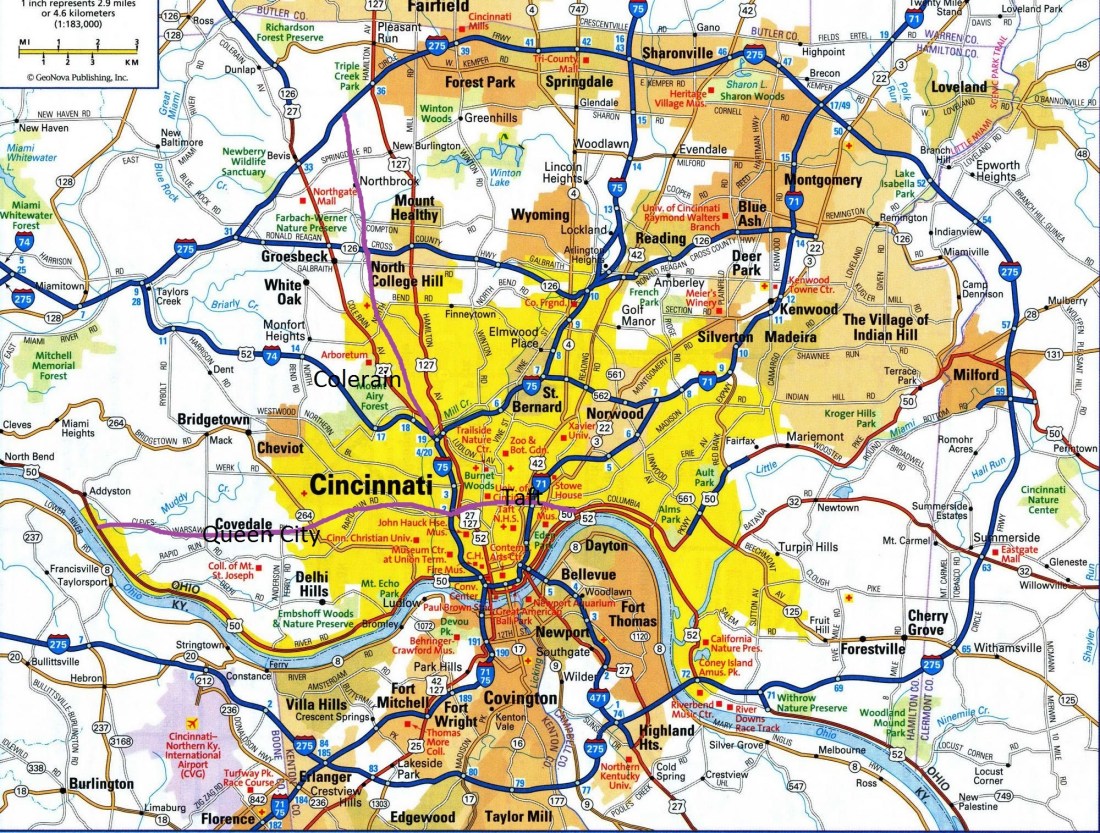
The Cross County was not the only expressway to fail to see completion in Cincinnati.  Just as local historians point out the existence of more than seven hills, so too were there more than the seven aforementioned freeways.  Three in particular hardly made it beyond the planning stages: the Colerain, the Taft, and Queen City freeways were all scrapped in their early stages.

Finding information on these scrapped freeways online isn’t easy, but reader David, a Cincinnati native, kindly sent me some relevant links.  According to the website Cincinnati-transit.net, the Taft expressway was to have run along nearby William Howard Taft Road, with its western terminus at the I-75/Western Viaduct/Harrison Ave. interchange (Exit 2B), and its eastern terminus at Columbia Parkway (U.S. 50), most likely near Torrence Parkway, with additional interchanges at Ravine Street, Vine Street , I-71, Gilbert Avenue, Victory Parkway, and Woodburn Avenue.

taftexpressway-map3

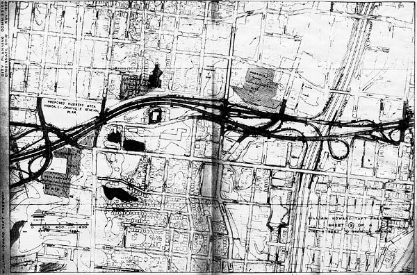
Map of the proposed Taft freeway showing some of the proposed interchanges, including Vine Street and I-71.

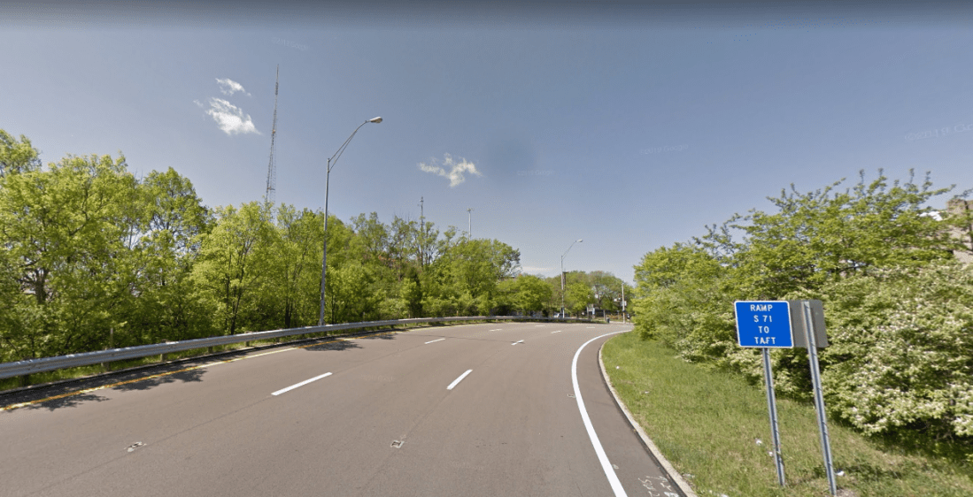
Although there isn’t a whole lot of physical evidence to support the planned construction of the Taft, one tantalizing piece is the I-71/Taft Rd. interchange (Exit 3A).  The off-ramp on southbound I-71 is exceptionally long, and then widens to three lanes before reaching the first stoplight:

I71TaftRoad


The Queen City expressway would have begun on the opposite side of the I-75/Western Viaduct interchange, traveling west and presumably running near Queen City Avenue and Cleves Warsaw Pike.  Proposed exits would have included Grand Avenue, Quebec Road, Queen City Avenue, Glenway Avenue, and Anderson Ferry Road.

53 Western Hills Viaduct - Google Maps

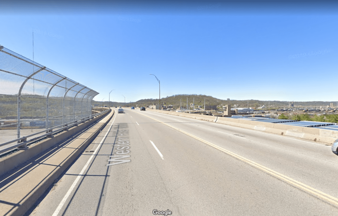
Facing west on the Western Hills Viaduct, near I-75.  This would have been the eastern terminus for the Queen City Freeway.

Finally, there was the proposed Colerain Expressway, which would have connected I-74 at the Colerain Avenue (U.S. 27) interchange with I-275 between Colerain and Hamilton Avenues, with interchanges at Compton Road, Galbraith Road, and North Bend Road.

colerain2

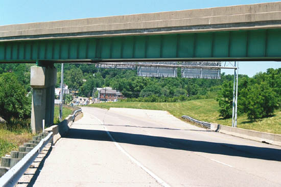
Looking northwest at the Colerain/I-74 interchange.  Note the ramp stubs for the proposed  Colerain freeway.  Photo courtesy of Cincinnati-transit.net.


The following map would give you some sense of where all the freeways would have been located, lined in purple:

cincyfreewaymap


Well, that’s enough for our “Ohio Tour” for now.  Next, we will head out east to Pennsylvania and upstate New York.  Plenty more to discover there!


Additional sources:

https://www.cincinnati.com/picture-gallery/news/local/2018/04/26/a-visual-history-of-cincinnati-transportation/33773547/

https://en.wikipedia.org/wiki/Interstate_75_in_Kentucky

http://www.cincinnati-transit.net/never-built.html

https://www.cincinnati-oh.gov/planning/assets/File/2001_northside_colerain_connector_land_use_plan.pdf

https://www.wcpo.com/news/our-community/from-the-vault/from-the-vault-why-cincinnatis-airport-is-in-kentucky-70-years-after-first-flights

https://books.google.com/books?id=P641AQAAMAAJ&pg=SA1-PA6&lpg=SA1-PA6&dq=cincinnati+ohio+state+route+126+history&source=bl&ots=Da9g—b-C&sig=ACfU3U39nB02Z-CysukdUtTAD36MWYv6Ng&hl=en&sa=X&ved=2ahUKEwiYv4mYit_pAhWEbc0KHXRTDekQ6AEwBHoECAsQAQ#v=onepage&q=cincinnati%20ohio%20state%20route%20126%20history&f=false

https://en.wikipedia.org/wiki/Highway_revolts_in_the_United_States#Cincinnati

https://dir.md/wiki/Ronald_Reagan_Cross_County_Highway?host=en.wikipedia.org

Not Quite Halfway There: Dayton, Ohio’s I-675 Bypass

Resuming from a long break, we continue down I-75, arriving in Dayton, Ohio, which is best-known for the Wright Brothers, who would pioneer a whole new mode of transportation for the 20th and 21st century.  Dayton proved to be no slouch either when it came to ground transportation, either.  According to Wikipedia, Dayton’s downtown road system is unlike most other Midwestern cities its size: the streets are very broad, with two to three lanes running in each direction, with ample space for pedestrians and cyclists.

25_S_Main_St_-_Google_Maps_-_2019-03-17_18.10.05

View of South Main Street in downtown Dayton.

Dayton’s freeway system is also unlike its neighboring cities of Columbus, Cincinnati, and Indianapolis.  From a strictly logical standpoint, Dayton’s freeway network might have made more sense if it had been built like this:

dayton2d

Instead of looking like what it ended up with:

dayton2

As you can see from the above map, Interstate 70, one of the longest east-west highways in the United States, misses the city of Dayton entirely, traversing its northern suburbs instead.  This might not have been unintentional, since I-70 in Ohio was built to replace traffic along U.S. Highway 40.

What’s really odd about Dayton is that up until the mid-1990s, there were hardly any freeways in the western part of the metro area.  Eastern Dayton, in contrast, had several expressways crossing its terrain, including U.S. Highway 35, Ohio State Route 4, and Ohio State Route 844 (a spur freeway that connects to Wright-Patterson Air Force Base), and I-675.  I-675 appears as a somewhat malformed semi-circle, connecting I-75 south of Dayton with I-70 near Springfield.

It might be helpful at this point to explain the rationale of three-digit interstates in the United States and why they are numbered the way they are.  As a general rule, three-digit interstate highways that begin with an odd number (like 1, 3, 5, and 7) are known as “spur” interstates — they connect the two-digit “parent” interstate with a city’s downtown or central business district (such as I-175, I-375, I-575, etc.)  In contrast, three-digit interstates that begin with an even number (2, 4, 6, and 8) are usually “by-pass” or “loop” interstates — going around a city, usually to avoid potentially heavier traffic within the central business area (like I-275, I-475, etc,) and re-connecting with the “parent” two-digit interstate at both ends.  Wikipedia has a helpful visual:

1280px-FHWA_Auxiliary_Route_Numbering_Diagram.svg


Not all three-digit interstates follow these rules, however, and I-675 in Dayton is one of them.  Of course, there’s a story behind all of this. So what happened?  First, let’s again go back to the planning stages that took place in the 1950s and 1960s.  For this particular article, I have to give enormous credit to the author at Daytonology.com (http://daytonology.blogspot.com).  Although his website has not been updated in a very long time, and at one point he even voiced  his intention to take the site down, supportive fans and readers pleaded with him to leave it as it was, and because of that decision we still have access to a treasure trove of information about the  Dayton area.  Major credit is also due to user “Jeff” at the forums of urbanohio.com, who also has a wealth of old city maps in his posts.

Before World War 2, Dayton, along with many other cities in the United States, was pre-occupied with how to alleviate heavy traffic and congestion in its downtown area.  Talk of creating a network of parkways was proposed as far back as the 1920s, but by the end of the war the discussion had shifted to building a network of higher-speed, limited-access freeways instead.  As we’ve seen before in places like Winnipeg, extensive research was conducted to study the traffic patterns of the city, and where the construction of such highways would provide the most benefit.

imageproxy.php

As you can see from the above map, traffic was particularly heavy along U.S. Highway 25 and Ohio State Route 4.  What gets interesting here is the debate Dayton had over where else freeways should be built.  By the late 1950s the city had decided on a “hub and spoke” network, with multiple freeways radiating from the downtown area:

I6754A

Not long after the above plan had been proposed, however, that calls were made for Dayton to have a proper by-pass expressway around the downtown, and by 1962 plans were in place for Interstate 675, which would have connected to I-75 in Miami Township at its southern terminus, and then re-connecting with I-75 in Northridge at its northern terminus:

I6755A

What then followed over the coming years proved to be a series of messy politics, as the author of Daytonology points out in his series of articles.  The original route for I-675 overlapped most of its length with the proposed Southeast Freeway.  While the Ohio Department of Transportation signed off on its approval for the plan, the Bureau of Public Roads (a precursor to the Federal Highway Administration) would not, citing the proposed I-675 as a “parallel expressway” — as a result, Dayton was unable to secure federal funding for the project.I6757

By 1965, the proposal for I-675 had evolved to its present day course, swinging to the eastern suburbs around Wright-Patterson Air Force Base and the newly-built Wright State University Campus.  Real-estate speculators, it was believed, would also benefit from the altered route.  But again, the federal government would only pay for 50 percent of the funding for the new highway — it was up to the state of Ohio and local governments to come up with the rest of the money.  As a result, Dayton re-allocated funding that would have gone to freeway development on the western side of the metro area, and used it to complete I-675.  Although I-675 was originally slated for completion in 1975, further delays and controversies resulted in the highway not being finished until 1989.  The conflict reached a crescendo during 1979, when the Ohio Department of Transportation threatened to sue then-Transportation Secretary Neil Goldschmidt.  Goldschmidt had agreed only to fund construction of I-675 only between I-70 and U.S. Route 35.  The state government accused Goldschmidt of “a usurpation of the authority of local and state governments to determine the destiny of their highway system.”  However, Thomas Downs, who was then a planner for the Federal Highway Administration, cautioned the city of Dayton and the state of Ohio against taking legal action against the Transportation Secretary, arguing that the courts had sided with the federal government numerous times over similar incidents.

“All politics is local,” as the saying goes.  Maybe not, but Dayton’s long road with Interstate 675 is a prime example of how federal, state, and local politics collided with each other to make the United States highway system what it is today.

DaytonI-675

View of I-675 near Wright-Patterson AFB and Wright State University.

Additional Sources:

https://en.wikipedia.org/wiki/Dayton,_Ohio

https://maps.google.com

https://www.kurumi.com/roads/3di/3di-primer.html

http://daytonology.blogspot.com/2008/09/long-road-to-road-i-675-prehistory-to.html

http://www.interstate-guide.com/i-675-oh/

https://www.daytonohio.gov/DocumentCenter/View/290

https://forum.urbanohio.com/topic/1941-dayton-expressway-prehistory/

https://newspaperarchive.com/xenia-daily-gazette-dec-11-1979-p-1/

On the Waterfront: Toledo, Ohio’s Downtown Distributor Freeway

Traveling south on  I-75 from Detroit, we arrive a mere 60 miles away in the Midwestern city of Toledo, Ohio, which also happens to be the native home town of yours truly.  As a young person on the city’s west side, I remember feeling confused whenever I would look at maps of my neighborhood and see streets stop at the edge of Interstate 475, only to start up again on the other side of the expressway.  Hadn’t anyone ever thought to build bridges when these streets were built?  Of course, my memory only went back to about 1980 or so, and so I had to rely on my mother to help fill in the “missing history” that I didn’t know about.  My mom, who also grew up on the west side, told me the story of how, in the late 1960s, certain houses were painted with large “X”es on their front side in her neighborhood — these were the homes that were to be marked for demolition to make room for the new freeway.

While the boom of freeway construction in Toledo happened during the 1960s and 1970s, like many other American cities, plans for the area had been in consideration for many years.  Many thanks need to go to the author of Toledohistorybox.com for providing this info.  (for you native Toledoans out there, be sure to check out his site!  Lots of interesting history!)  The 1949 freeway plans looked quite a bit different from what was ultimately built:

toledo 1949map

For those of you who are familiar with the Toledo area, you can see the U.S. 25 Expressway (later I-75), was originally planned to cross the Maumee River just east of downtown Perrysburg, travel along the Anthony Wayne Trail as it approached downtown, and then skirt north of downtown  near the Buckeye Basin and Mulberry Park before turning north again towards Detroit.  The U.S. 20 Expressway (later I-80 and I-90) was re-routed south when the Ohio Turnpike opened in 1955, though the western portion in the city limits would later be re-designated as I-475.  The Cleveland Detroit Bypass (later I-280) was originally planned to run only from the area near Woodville Road to just north of downtown.

By the mid-1960s, plans had been altered to the point that the Toledo freeway system developed to its present day layout.  One issue remained to be decided: how to get commuters in and out of downtown more efficiently.  Rush-hour traffic would routinely jam the streets, and plans were discussed to build an additional expressway that would link I-75 with I-280 via downtown.  Several routes were considered:

toledo downtown distributor expressway-05

In 1964, the Toledo city council gave approval to construct the Downtown Distributor Freeway on the southernmost route, placing it along the Maumee River, with the designation of Ohio State Route 112.

toledo downtown distributor expressway-02

Plans were also discussed to add an additional spur to the Distributor, which would have allowed traffic on southbound I-75 to exit off directly on to the Anthony Wayne Bridge, thus providing easier access to the city’s east side:

toledo downtown distributor expressway-08


toledo downtown distributor expressway-09

An artistic rendering of the western portion of the Downtown Distributor Freeway, drawn up by the engineering firm Howard, Needles, Tammen, and Bergendoff.  The freeway was planned to be elevated between the I-75/Washington St. Interchange and Summit Street before descending to ground level.

In 1970, the Toledo Blade followed up with an endorsement of the planned freeway in its editorial page, after commenting favorably on the newly opened I-475:

“What [I-475] will demonstrate…is the need to expedite the planning and construction of the first phase of the downtown distributor.  This is the key link that will carry the heavy volume of traffic into the central business district…bogged down by indecision, changing plans, and disagreement over routes, this distributor is still a number of years away; meanwhile, thousands of drivers who will be using the expressway in the downtown area are simply going to have to move from and to it over narrow city streets that were never designed to handle the volume expected.”

Although there were still plans to construct the first phase of the Distributor (from I-75 to Summit Street) as late as 1972, discussion soon fell off the map.  The Distributor would likely have had multiple environmental impacts on the downtown area, including the removal of multiple housing projects and commercial businesses in its path, which also would have led to increased financial costs for the city.

Today, there is little evidence remaining of the planned Downtown Distributor.  The ramp stubs at I-75 at Washington Street, which would have marked the western end of the freeway, were apparently removed years ago.  The eastern end of the freeway would have intersected at the I-280/Summit Street Interchange, which was removed in 2007 when the Veterans’ Glass City Skyway Bridge opened to traffic — the upside being a newly re-constructed I-280 that was considerably safer to travel on.

1628_N_Summit_St_-_Google_Maps_-_2019-02-14_15.19.18

View of the re-built I-280/Veterans’ Glass City Skyway from Summit Street.  The Craig Street Bridge, which carried traffic on the old I-280, is visible below the new bridge and is open to cyclists and pedestrians.

That might be the end of the story, but there is another interesting wrinkle:  later on in the 1970s, plans were devised to construct the Buckeye Basin Greenbelt Parkway, which would replicate some of the functionality of the original Downtown Distributor.  The original plan was for the parkway to connect downtown Toledo with the northeastern most area of the city, Point Place.  Construction began in 1996.  Political controversy over the potential of destroyed environmentally-sensitive wetland areas eventually put a halt to the Greenbelt Parkway as well, which currently ends at Galena Street, just east of I-280.  As was the case with Detroit, even automobile-friendly cities like Toledo can decide that they’ve reached their limits when it comes to new highway construction.

Greenbelt_Pkwy_-_Google_Maps_-_2019-02-14_15.23.14

Heading towards downtown Toledo on the Greenbelt Parkway, near Mulberry Park.

Additional Sources:

https://www.toledohistorybox.com/images/expressway.pdf

https://www.toledohistorybox.com/2017/09/23/interstate-475-opens-through-west-toledo/

https://en.wikipedia.org/wiki/Ohio_Turnpike

https://news.google.com/newspapers?id=W_cjAAAAIBAJ&sjid=5QEEAAAAIBAJ&pg=1038%2C5450274

https://books.google.com/books?id=j202AQAAMAAJ&pg=PA1&dq=toledo+%22downtown+distributor%22&hl=en&sa=X&ved=0ahUKEwidoJXNxMHgAhUTtIMKHSVXC30Q6AEILDAB#v=onepage&q=toledo%20%22downtown%20distributor%22&f=false

https://caselaw.findlaw.com/us-6th-circuit/1317419.html

Motor City Landmark: Detroit’s Davison Freeway

Traveling from the capital of the federal government to the capital of the automobile industry, we arrive at the largest U.S. city on the Canadian border. Detroit, Michigan has been known for its spectacular rise and fall throughout the 20th century.  The “Motor City” was not only an enormous hub for the car industry, but also home to Motown, which launched the careers of many famous African-American musicians.  Detroit is also home to many professionals sports teams (the Lions, Pistons, Tigers, and Red Wings) who each have their cohort of die-hard fans.  Detroit is also a “melting pot” of many peoples from around the world, and there are a slew of ethnic restaurants bound to satisfy anyone’s taste (Chinese, Greek, Italian, Mexican, Middle Eastern, and Polish eateries abound).

Yet in spite of all these assets, Detroit struggled mightily during the latter half of the 20th century.  The population declined from a peak of 1.86 million in 1950 to a little over 700,000 today.  It’s no surprise that most major cities in the so-called “Rust Belt” saw major declines over the last 60 years, but Detroit was hit especially hard.  If you ask people why Detroit has had such problems in recent decades, you are bound to find multiple answers: from automation in the automobile industry, to racial tensions and the urban riots of the 1960s, to corporate greed, to the decline of unions (or stranglehold of unions, depending on who you ask), to the accusations of corruption and incompetence of city governments over the years.  The fallout from all these events have led to a particular bitterness and hostility between different sides in Detroit’s politics.  Is there a way out?  Possibly.  Efforts are under way to revitalize the city, and perhaps there may come a day when Detroiters can overcome their differences and work together to get the Motor City back on its feet.

It should surprise no one that Detroit, being the hub of the nation’s auto industry, was way ahead of other cities when it came to planning high-speed motorways: the city can arguably claim to have built the first urban expressway in the United States.  As a result, the Davison Freeway has had a longer history, with more twists and turns, than the other projects that have been covered so far on this site.

google_maps_-_2019-01-26_13.46.54

The story of the Davison starts way back in 1940.  At that time, Davison Avenue was a busy corridor, shuttling commuters back and forth between Detroit and its northern suburb of Highland Park.  Traffic had reached a point of gridlock, and in 1941 the Highland Park city council voted to rebuild the road as a freeway, and demolition commenced for over 130 homes located along the avenue.  By the end of 1942, the freeway was completed and opened to traffic, with a total length of 7000 feet (about 1.25 miles long).

davison freeway construction - 1942

Demolition and widening of Davison Avenue during freeway construction.


id3024_davison

The Davison Freeway shortly after being opened to traffic.

The Davison was only a drop in the bucket to what was planned for the city of Detroit.  Even before the end of World War 2, Detroit already had plans on the board for multiple expressways to cross every section of the city.

detroit plans - 1943

As the 1940s and the 1950s passed, Detroit scaled back its freeway plans somewhat, and the layout started to resemble the network that is in place today:

detroit-planned-highways

As you can tell from the above maps, the Davison Freeway was only the start of what was to come.  The Vernor and Conner Freeways were never built, and opposition to the proposed freeway along Grand River Avenue later caused I-96 to be re-routed along Schoolcraft instead.  In 1957 the Davison Freeway was extended west to connect with the newly-opened Lodge Freeway (U.S. Highway 10), and in 1968 was extended east to Conant Street, also connecting with the I-75/Chrysler Freeway, which had just been finished.  The Davison had now more than doubled in total length to 2.85 miles.  Although plans for some of the other freeways in Detroit had been scrapped by the late 1960s, transportation planners were hoping to extend the Davison Freeway further west to meet up with I-96, as well as further east to Mound Road.


rr168pl_168_534100_7-12

1967 Michigan DOT plans for the Detroit/Ann Arbor freeway system.  Note the plans to extend the Davison further west and east, along with a greatly (!) extended M-53/Van Dyke Freeway that would have run to the edge of downtown Detroit.

As late as 1973, E.V. Erickson, who was the chairman of the State High Commission in Michigan, advocated for the extension of the Davison, along with 13 other freeways throughout the state.  The proposed highways were to be built using funds from Governor William Milliken’s transportation package.  However, local opposition to further freeway construction, which had been brewing for years, led Mayor Coleman Young and the Detroit City Council to ax the extension for the Davison.

By the mid-1990s, questions arose as to what the fate of the Davison would be.  The freeway was closed by that point, due to the antiquated and unsafe conditions  of the road: high volume of traffic , no shoulders, narrow lanes and a narrow median had all conspired to make the Davison unable to meet modern safety rules and regulations.  Incredibly the original concrete had held up well over its 50-year lifespan.  What to do?  There was some talk of filling in the depressed freeway and converting the Davison back into a city avenue, although, interestingly enough, there was significant opposition to this idea by residents of both Detroit and Highland Park.  After some back-and-forth political tussling between Governor John Engler and local leaders, the Davison was renovated as a modern-day eight-lane freeway, with wider shoulders and a concrete barrier in the median.  Maintenance of the highway was transferred from local to state control, and the Davison was thus designated as Michigan State Route 8.   The re-constructed freeway was re-opened to traffic in 1997.


davison_fwy_-_google_maps_-_2019-01-20_11.53.21

Facing eastward on the reconstructed Davison Freeway.


detroit,_michigan_-_google_maps_-_2019-01-26_12.53.49

Facing east at the I-96/Davison Avenue interchange.  Note the presence of the wide median, multiple lanes, and on/off-ramps — evidence that the Davison Freeway was originally planned to extend further west to I-96.

Additional sources:

http://www.atdetroit.net/forum/messages/6790/43221.html?1159540884

http://www.dailydetroit.com/2016/08/03/detroit-home-americas-first-urban-freeway/

http://www.michiganbuildingtrades.org/newspaper/davison-nations-first-freeway-was-built-right-the-first-time

https://www.michigan.gov/documents/mdot/RR168PL_168_534100_7.pdf

http://www.michiganhighways.org/listings/M-008.html

https://en.wikipedia.org/wiki/M-8_(Michigan_highway)

https://maps.google.com

Holland Evening Sentinel – March 12, 1973 – page 7

https://en.wikipedia.org/wiki/Highway_revolts_in_the_United_States#Detroit

Here, There, and Everywhere: Washington D.C.’s Many Unbuilt Highways

For the end of 2018, we conclude with a post on the nation’s capital.  With the recent announcement of Amazon.com planning to build new headquarters in Crystal City, Virginia, local citizens and officials have questioned whether the transportation system of  Washington, D.C. can handle the increased load on its system.  The D.C. Metro has been criticized for years — with many residents of the area arguing that the iconic subway/local rail system is not far-reaching and comprehensive enough to meet the needs of many commuters.

dc_metro_map

The history of the D.C. Metro is also intertwined with the history of the freeway system in the nation’s capital — namely, that some of the Metro lines were built along corridors where Interstate highways might have run.  Critics might argue that Washington D.C. has the worst of both worlds: an inefficient, incomplete rail system combined with an inefficient, incomplete expressway system.  Whether you commute by car or without a car in D.C., you’re likely to run into hassles and headaches.

DC traffic

If you want to live in Washington D.C., you better get used to a busy commute!


What makes Washington so unique from every other city in the United States, besides being the seat of the federal government?  A lot of it has to do with the transportation system.  Much of the planning for the city’s original layout was borne from the mind of one man, a French military engineer by the name of Pierre L’Enfant (1754-1825).  L’Enfant had a logical plan for the layout of the District of Columbia:  streets that ran north-south would have a number (1st, 2nd, 3rd, etc.) while streets that ran east-west would have a letter (A Street, B Street, etc.).  Streets that ran in a diagonal manner would be christened as as avenue with one of the state names (Pennsylvania Avenue, New York Avenue, etc.)  You can read more details of this plan in a fascinating article at curbed.com here.

All very sound and orderly, but when it came time for Washington, D.C. to come up with its own freeway plan in the mid-1900s, the process was anything but.  Numerous changes and revisions were made, and to this day, much of the D.C. freeway system, especially around the downtown areas, lies in bits and pieces.


District_of_Columbia_1955_Yellow_Book

Plans from 1955 Yellow Book


Basic Freeway Plan 1958

1958 Plans


DC_Area_Map_XL_1971_plans

1971 Plans


While it isn’t possible to cover all the canceled/altered/abandoned highway projects in one post, here are some of the more notable ones:


I-95:

Currently I-95 runs along the eastern half of the I-495 beltway, but this was not the original plan.  As we saw with I-40 in Memphis, I-95 was to have made a direct cut through the city.  The original plan (coming up from the south) was for I-95 to cross the beltway, travel the entire length of I-395, and then turn northeast, eventually merging with the College Park/I-495 beltway interchange.  The “Northeast Freeway” had several different proposed routes.  The latest one, from the early 1970s, would have had I-95 as an eight-lane freeway running through the North East sector of the city along the Pepco power line and B&O Railroad corridors.  You can see evidence for the continuation of I-95 inside the beltway by the “over-engineered” interchange at College Park, which takes south-bound drivers to a Park and Ride on the Metro Green Line:

Google_Maps_-_2018-12-25_14.24.37


I-70S:

part of the proposed North Central Freeway.  Before 1975, I-270 in Maryland was designated I-70S.  While it currently terminates at the northwest corner of the I-495 beltway in North Bethesda, plans existed to extend the freeway into D.C. itself.  Originally the freeway was to run along the same route as Canal Road and the Clara Barton Parkway before meeting up with I-66.  The proposed route was then changed, with I-70S traveling along the I-495 beltway before turning south near Takoma Park, eventually merging with then-proposed I-95 In the North East part of D.C.  The freeway was to be six lanes and travel parallel with the B&O railroad, with a cleared right-of-way.  Residents of D.C. and Takoma Park stridently and occasionally violently opposed the highway, concerned over proposed demolitions in the Woodside Park and Sligo Creek Park neighborhoods.  The proposed highway was abandoned in the early 1970s.

I-66:

Also known as the North Leg Freeway.  Up until the 1970s, plans existed to extend I-66 eastward by 1 1/2 miles from its current terminus at U.S. 29 and K Street.  I-66 was to have run via tunnel underneath K Street before emerging at ground level to merge with I-95 (currently designated I-395) near New York Avenue.

dc_stage7

Map of the proposed I-66, I-95, and I-295 extensions in the central part of D.C. 

Inner Loop 1280

A slightly modified proposal showing more detail.

I-266: 

Interstate 266 was to have been a short connecting freeway running much of its length along the Potomac River.  The western terminus was supposed to have been where Sprout Run Parkway crosses I-66 in Arlington, Virginia.  From there, I-266 was to run along the current route of Sprout Run, cross over the Potomac along the proposed Three Sisters Bridge, and then turn east, running along Canal Road NW before merging again with I-66 near Rock Creek and Potomac Parkways and K Street.  Strong, and occasionally violent protests against the planned Three Sisters Bridge during the 1960s and 1970s caused the I-266 plan to be abandoned.  The only segment of the proposed freeway to see completion became known as the Whitehurst Freeway (U.S. Route 29), which runs  for approximately 0.8 miles.


I266 three sisters bridge map

Proposed route for the western segment of I-266.


three sisters bridge

An artistic rendering of the proposed Three Sisters Bridge in Arlington.

I-295:

Also known as the Anacostia Freeway.  Originally intended to follow the route of I-695 and become part of the “Inner Belt” in downtown D.C.  Other proposals had the interstate running along D.C. Route 95.

I-695:

Interstate 695 is only two miles long, but there were plans to extend the highway further east as well as west.  During the 1960s proposals were made to extend I-695 west, which would have brought it in the vicinity of the Washington Monument and Lincoln Memorial along Maine and Independence Avenues, before terminating at I-66 near the Constitution Avenue interchange:

dc-plans


In the 1990s another proposal was made, this time to extend the freeway east along Southeast Boulevard, eventually merging with D.C. Route 295.  The goal was to relieve congestion on the heavily-traveled John Philip Sousa Bridge.


Southeast_Blvd_-_Google_Maps_-_2018-12-25_16.44.28

Southeast Boulevard exiting off to Pennsylvania Avenue.  The highway at left, which runs under the Penn. Avenue overpass to RFK Stadium, was originally intended as an eastern extension of I-695.


I-595:

Interstate 595 was originally conceived as a spur freeway linking I-395 with Reagan National Airport in Arlington.  It was to have followed the same path as current U.S. Highway 1.  The route was never upgraded to Federal Interstate Highway standards.


DC-planned-freeways

Wikimedia map showing some of the various highway proposals for Washington D.C. during the 1950s – 1970s.

With the advent of Amazon.com coming to town, it will be fascinating to watch the city’s debate over transportation continue and what plans will be approved going forward.

Thanks to all you great readers for an exciting journey here in 2018!  Rest assured, there will be much more to post in the new year!


Additional Sources:

https://commons.wikimedia.org/wiki/File:DC_freeway_map.svg

https://www.fhwa.dot.gov/highwayhistory/data/page05.cfm

https://en.wikipedia.org/wiki/Washington_Metro

https://dc.curbed.com/2014/8/13/10061100/facts-and-myths-about-dcs-street-system

http://www.vahighways.com/route-log/i266.htm

https://www.washingtonpost.com/archive/politics/1978/10/30/no-new-freeways-slated-for-district/73617023-5f32-4617-99ae-edf7eab5192a/?utm_term=.ac20df4dc53b

http://wwwtripwithinthebeltway.blogspot.com/2007/03/georgetowns-waterfront-freeway.html

https://en.wikipedia.org/wiki/North_Central_Freeway_(Washington,_D.C.)

https://en.wikipedia.org/wiki/Interstate_270_(Maryland)#History

https://en.wikipedia.org/wiki/Interstate_66#District_of_Columbia_2

https://en.wikipedia.org/wiki/Northeast_Freeway_(Washington,_D.C.)

http://wwwtripwithinthebeltway.blogspot.com/2007/04/1971-dc-b-i-70s-i-270-takoma.html

http://www.fosc.org/NCFreeway.htm

http://www.dcroads.net/roads/southeast/