Traveling south on I-75 from Detroit, we arrive a mere 60 miles away in the Midwestern city of Toledo, Ohio, which also happens to be the native home town of yours truly. As a young person on the city’s west side, I remember feeling confused whenever I would look at maps of my neighborhood and see streets stop at the edge of Interstate 475, only to start up again on the other side of the expressway. Hadn’t anyone ever thought to build bridges when these streets were built? Of course, my memory only went back to about 1980 or so, and so I had to rely on my mother to help fill in the “missing history” that I didn’t know about. My mom, who also grew up on the west side, told me the story of how, in the late 1960s, certain houses were painted with large “X”es on their front side in her neighborhood — these were the homes that were to be marked for demolition to make room for the new freeway.
While the boom of freeway construction in Toledo happened during the 1960s and 1970s, like many other American cities, plans for the area had been in consideration for many years. Many thanks need to go to the author of Toledohistorybox.com for providing this info. (for you native Toledoans out there, be sure to check out his site! Lots of interesting history!) The 1949 freeway plans looked quite a bit different from what was ultimately built:

For those of you who are familiar with the Toledo area, you can see the U.S. 25 Expressway (later I-75), was originally planned to cross the Maumee River just east of downtown Perrysburg, travel along the Anthony Wayne Trail as it approached downtown, and then skirt north of downtown near the Buckeye Basin and Mulberry Park before turning north again towards Detroit. The U.S. 20 Expressway (later I-80 and I-90) was re-routed south when the Ohio Turnpike opened in 1955, though the western portion in the city limits would later be re-designated as I-475. The Cleveland Detroit Bypass (later I-280) was originally planned to run only from the area near Woodville Road to just north of downtown.
By the mid-1960s, plans had been altered to the point that the Toledo freeway system developed to its present day layout. One issue remained to be decided: how to get commuters in and out of downtown more efficiently. Rush-hour traffic would routinely jam the streets, and plans were discussed to build an additional expressway that would link I-75 with I-280 via downtown. Several routes were considered:
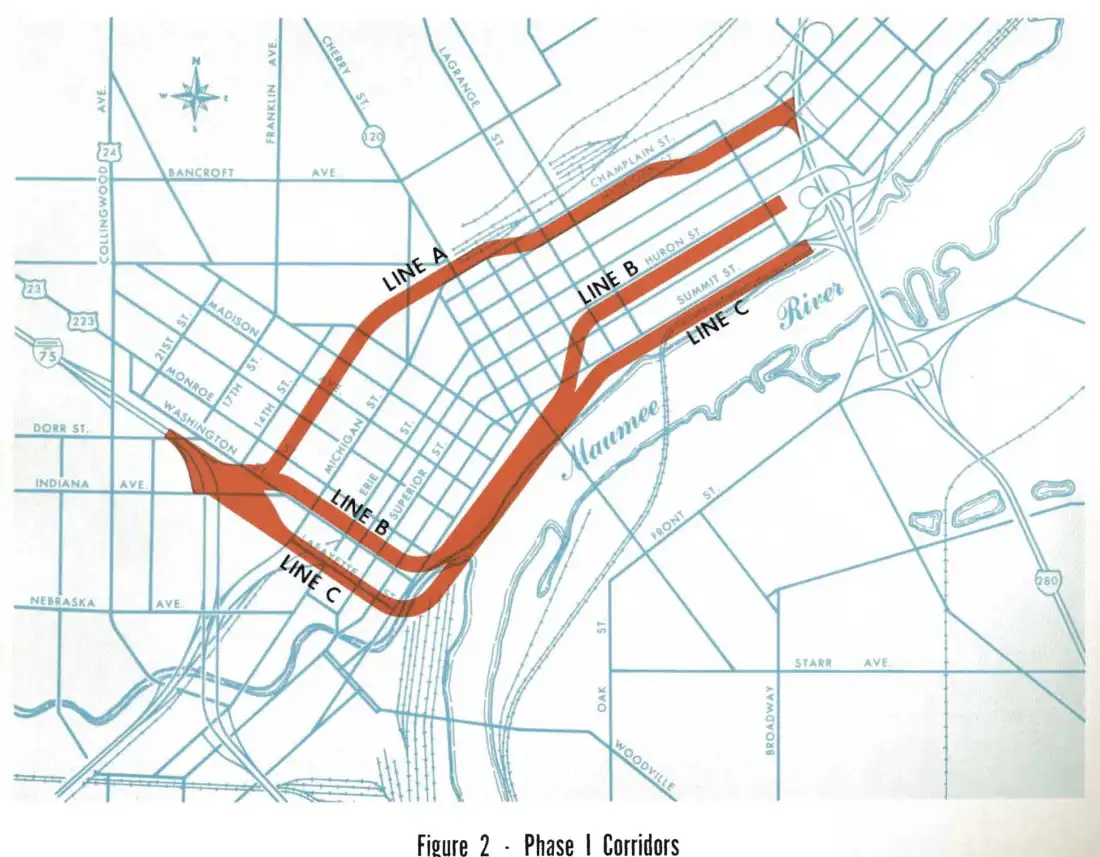
In 1964, the Toledo city council gave approval to construct the Downtown Distributor Freeway on the southernmost route, placing it along the Maumee River, with the designation of Ohio State Route 112.
Plans were also discussed to add an additional spur to the Distributor, which would have allowed traffic on southbound I-75 to exit off directly on to the Anthony Wayne Bridge, thus providing easier access to the city’s east side:


An artistic rendering of the western portion of the Downtown Distributor Freeway, drawn up by the engineering firm Howard, Needles, Tammen, and Bergendoff. The freeway was planned to be elevated between the I-75/Washington St. Interchange and Summit Street before descending to ground level.
In 1970, the Toledo Blade followed up with an endorsement of the planned freeway in its editorial page, after commenting favorably on the newly opened I-475:
“What [I-475] will demonstrate…is the need to expedite the planning and construction of the first phase of the downtown distributor. This is the key link that will carry the heavy volume of traffic into the central business district…bogged down by indecision, changing plans, and disagreement over routes, this distributor is still a number of years away; meanwhile, thousands of drivers who will be using the expressway in the downtown area are simply going to have to move from and to it over narrow city streets that were never designed to handle the volume expected.”
Although there were still plans to construct the first phase of the Distributor (from I-75 to Summit Street) as late as 1972, discussion soon fell off the map. The Distributor would likely have had multiple environmental impacts on the downtown area, including the removal of multiple housing projects and commercial businesses in its path, which also would have led to increased financial costs for the city.
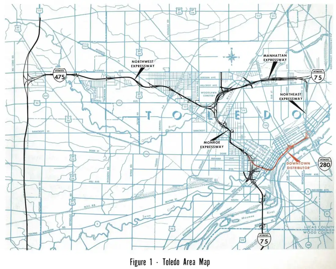
Today, there is little evidence remaining of the planned Downtown Distributor. The ramp stubs at I-75 at Washington Street, which would have marked the western end of the freeway, were apparently removed years ago. The eastern end of the freeway would have intersected at the I-280/Summit Street Interchange, which was removed in 2007 when the Veterans’ Glass City Skyway Bridge opened to traffic — the upside being a newly re-constructed I-280 that was considerably safer to travel on.

View of the re-built I-280/Veterans’ Glass City Skyway from Summit Street. The Craig Street Bridge, which carried traffic on the old I-280, is visible below the new bridge and is open to cyclists and pedestrians.
That might be the end of the story, but there is another interesting wrinkle: later on in the 1970s, plans were devised to construct the Buckeye Basin Greenbelt Parkway, which would replicate some of the functionality of the original Downtown Distributor. The original plan was for the parkway to connect downtown Toledo with the northeastern most area of the city, Point Place. Construction began in 1996. Political controversy over the potential of destroyed environmentally-sensitive wetland areas eventually put a halt to the Greenbelt Parkway as well, which currently ends at Galena Street, just east of I-280. As was the case with Detroit, even automobile-friendly cities like Toledo can decide that they’ve reached their limits when it comes to new highway construction.

Heading towards downtown Toledo on the Greenbelt Parkway, near Mulberry Park.
Additional Sources:
https://www.toledohistorybox.com/images/expressway.pdf
https://www.toledohistorybox.com/2017/09/23/interstate-475-opens-through-west-toledo/
https://en.wikipedia.org/wiki/Ohio_Turnpike
https://news.google.com/newspapers?id=W_cjAAAAIBAJ&sjid=5QEEAAAAIBAJ&pg=1038%2C5450274
