Even the band Weezer probably couldn’t make a hit song out of that…..
For some odd reason, a lot of “disaster” movies take place in Los Angeles, California. Why is that? Does it have to do with the city’s warm and sometimes unpredictable climate? Does the huge sprawling landscape of land and people of the area create a sense that bad things are more likely to happen there? Or is it because that Hollywood and the film studios are there, and therefore it’s probably more convenient and less costly to shoot on location? Who knows?
The transportation system of Los Angeles, while certainly not a disaster, can lend itself to a certain level of madness and chaos at times. Negotiating the thoroughfares of the L.A. area must feel like trying to find your way through a giant maze: according to L.A. Almanac, the California megalopolis has over 300 miles of federal Interstate highways, 200 miles of other freeways/expressways, and 2000 miles of principal arterial roadways. Even all that isn’t enough to deal with the crazy backups and congestion! What people who live in the City of Angels may not realize, however, is that L.A. doesn’t even crack the “Top Ten” of cities with the longest commute times. People in New York City, Chicago, Washington, Baltimore, and Atlanta actually take longer to get to work. Cold comfort (or, since we’re in California, warm comfort?) to the residents of the second -largest city in the United States.
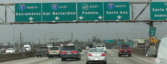
Designing a transport system for 18 million people is no small feat, especially when those 18 million likely have 18 million different destinations to get to! As a result, Los Angeles is fairly unique in that it has several spots where multiple freeways come together, including the “East L.A. Interchange” just southeast of downtown, where the I-5, I-10, U.S. 101, and State Route 60 freeways all come together in a rather dizzying manner.
Make sure you’re in the correct lane!
A bit of clarification is in order here. Why is it that, here in the United States, certain freeways have a Federal Interstate designation, others have a U.S. Highway designation, and yet others have a State Route designation? Hopefully I can get into more detail in a future post, but the answer primarily revolves around funding and maintenance — U.S. highways are primarily funded by Congress, and state routes are primarily funded by the state legislatures. More on that later…..
Anyhow, as impressive as all this is, it might be interesting to point out how much more grandiose the expressway system might have turned out for Los Angeles if the planners of the 1950s and 1960s had turned their California dreamin’ into reality. The L.A. Times has a neat interactive graphic that shows the freeways that were planned but never built, shaded in red:

Lookie, lookie, what do we have here?

A freeway running through Beverly Hills, California? Say it ain’t so! (with apologies again to Weezer….) The story of the Beverly Hills Freeway actually goes back a few years earlier, as this map from 1943 shows:
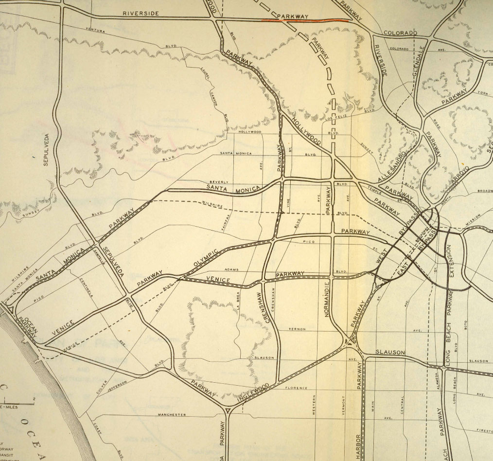
As you can see from the above, the freeway that was to run through Beverly Hills (the “Santa Monica Parkway”) would have connected the 405 ( then proposed as the “Sepulveda Parkway”) with U.S. 101 (then proposed as the “Hollywood Parkway”). Beginning at its western terminus from the edge of the Pacific Coast, the freeway was to run northeast, parallel with Santa Monica Boulevard, crossing over Wilshire Boulevard, and then turning east, straddling a path between Beverly and Wilshire before reaching its eastern terminus just east of the 101.
Why Beverly Hills, though, of all places? As we’ve seen with the Clark Freeway in Cleveland, it wasn’t just low-income communities that were affected by the interstate highway craze of the 1950s and 1960s — affluent neighborhoods also discovered that their prized homes were in line for the bulldozer as well. There actually was a certain logic to the highway also, which would have connected the Santa Monica Pier and Venice Beach on the coast with the Hollywood district. Last but not least, it is important to remember that back in the 1940s, Beverly Hills was actually a well-off but sleepy “bedroom community” of Los Angeles — it would be a couple decades before it became associated as the place of lavish wealth that people know it as today.
The same fate awaited the Beverly Hills Freeway as countless other highway projects during the 1960s, with local opposition stopping the plan in its tracks. Also of note is that since the freeway was a state route instead of a Federal Interstate, the city of Los Angeles was unable to access federal funds in order to complete the project, which had a projected price tag of $300 million. By 1975 the freeway through Beverly Hills was no longer on the drawing board.
Currently there are no signs of what was to become the proposed Beverly Hills Freeway, save for one: for travelers on the 101, there is a stretch between Melrose Avenue and Silver Lake Boulevard where the freeway has an inexplicably wide median. That’s no mistake: the median was built that way to accommodate what would have been on-ramps and off-ramps to the canceled freeway. There are no longer any plans for an “express way” to Beverly Hills — you might as well take Melrose or Wilshire and enjoy the scenery, even if it takes you longer to get there!

U.S. 101 near Vermont Avenue, where the Beverly Hills Freeway would likely have intersected.
Additional sources:
