Visiting our Canadian brethren to the north is not quite as simple as it used to be. I can remember the “early days” (i.e. pre-2001) when a jaunt across the border was pretty straightforward: when venturing from the States to Canada, you were usually asked a few brief questions by border agents. Then, assuming you were not up to anything questionable or suspicious, you were waved through to the land where the British monarch was still the head of state. Then came 9/11. Then came COVID-19, and new travel restrictions set in. Hopefully there will come a time when travel to see our northern neighbors becomes a little easier again.
In our last Canadian post, we traveled to Winnipeg in the province of Manitoba. This time, we journey to the much more populated province of Ontario. How much more? Almost 40 percent of the entire population of Canada lives there. Actually, HALF the entire population lives in the “Windsor – Quebec City corridor”, which is mostly connected by Highway 401 in Ontario and Route 40 in Quebec (also known by their “proper” names: the MacDonald-Cartier Freeway and the Autoroute Félix-Leclerc, respectively).
It’s important to remember that Canada never had a planned national highway system the way the United States did. Instead, the Canadian national government left such matters to the individual provinces to come up with and design their own highway networks. Being the most populated province, it obviously made the most sense for Ontario to come up with a high-speed limited-access network of expressways. What many people may not realize, however, is tha Canada was, in many ways, at the global forefront of highway development. Sean Marshall has a great article, “How Ontario Helped Invent the Modern Highway” to illustrate this example. A photo from that article:
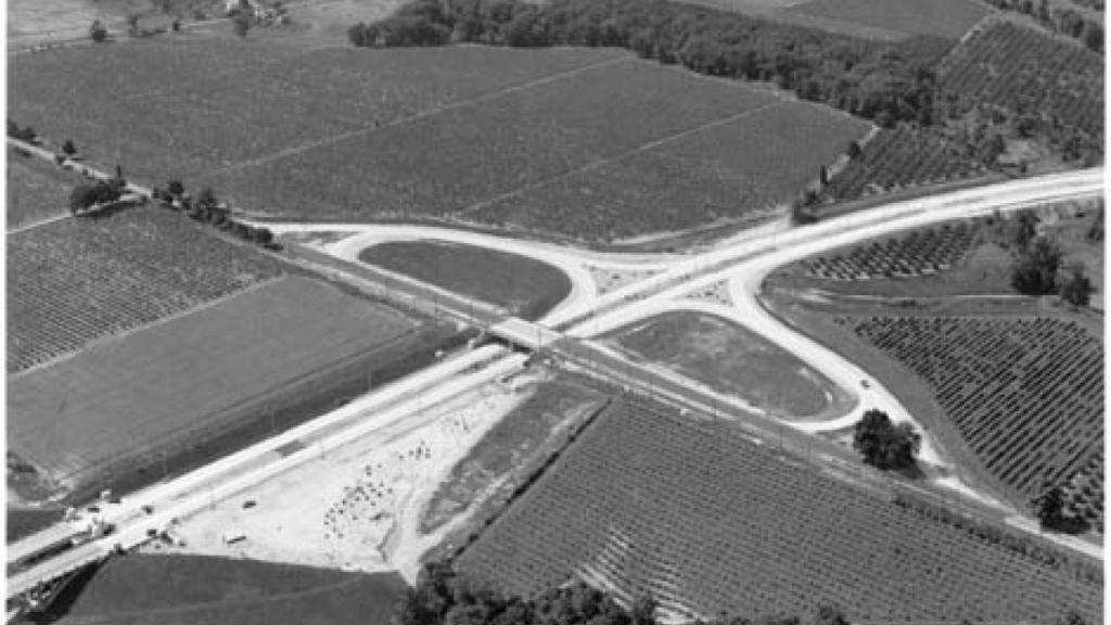
The above picture is of a “cloverleaf” design interchange of the Queen Elizabeth Way (QEW). All the more impressive when you realize that this photo is from 1940! As Marshall points out, however, it would be very wrong to think that one could drive on a modern freeway from Niagara Falls to Toronto in the early days of World War 2. When the first section of the QEW was completed in 1937, most intersections along the highway still made use of stop signs and traffic lights. It wouldn’t be until the 1970s when the entire length of the QEW was at long last upgraded to freeway standards.
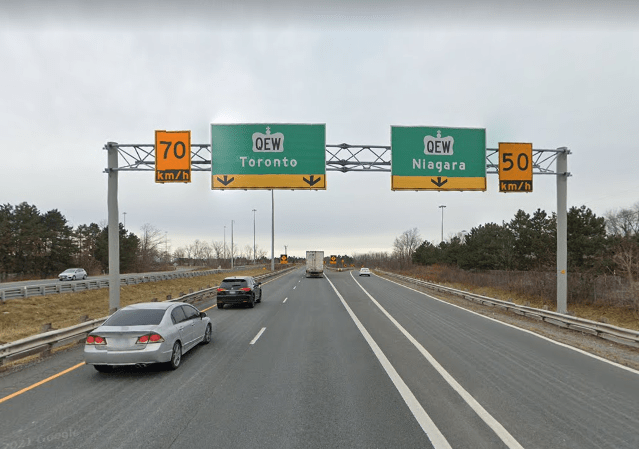
To this day, the QEW has one characteristic that sets it apart from every other modern freeway in North America: its absence of directional signage. That’s right: there are no markers for “north”, “south”, “east,” or “west” at intersections for the highway — rather, the cities are listed in place of the directions instead:
It’s easy for many of us on the U.S. side to forget that much of Canada is sparsely inhabited, and the northern topography of the Canadian countryside can make highway construction extremely daunting. The well-known Trans-Canada Highway, which was never assigned a national number, is practically built to expressway standards in parts of Ontario, but is an undivided meandering two-lane road in some of the other provinces. Some Canadians even argue that it’s often faster to travel from Vancouver to Toronto by entering the United States and driving I-90 and or I-94 to the 401 rather than use the Trans-Canada.
The province of Ontario has an extensive road system hierarchy. At the top of the list are the provincial highways, with the three-digit 400-series all built to modern freeway standards. The QEW is part of this system, with its designation as Highway 451, even though it is not posted on any signs. Below the 400 series are the “King’s Highways”, which are numbered from 2 to 148. Some of the King’s Highways are only 1 kilometer in length (0.6 miles), while Highway 17, which is Ontario’s section of the Trans-Canada, runs from the western border with Manitoba out to the eastern end of the province at 1964 kilometers (1224 miles).
After the King’s Highways, there is the 500 and 600-series, or the secondary highways. Then there is the 800-series, or tertiary highways. And then there is the 7000-series of highways, which tend to be unmarked. These four classes make up Ontario’s provincial highway system. Working down from the provincial level of the government, there are also the county roads, regional roads, municipal roads, district roads, and county highways.
The following map shows the freeways that existed in Ontario as of circa 2015:
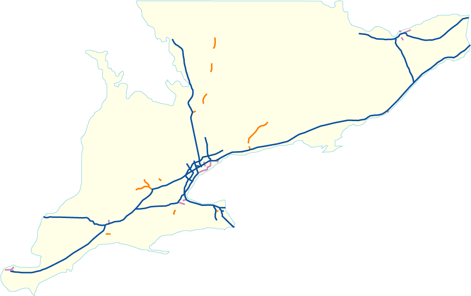
If you’re a little puzzled by this, remember: the blue lines are part of the 400-series highways, the purple lines are provincial expressways that are not part of the 400-series, and the orange lines are municipal expressways. Confused already? There are more expressways that are still in the planning stages, AND there are others that were not built at all, or at least not to completion. Our Canadian brothers and sisters sometimes do things on a different timetable than us Americans do, and we will explore that in a little more detail in upcoming posts.
Edit: It has been a *long* time since my last post. Due to recurring work and family issues, it’s been challenging to find time to write. Hopefully things are a little more settled now, and I look forward to posting in a more timely manner!
Additional sources:
https://www.tvo.org/article/how-ontario-helped-invent-the-modern-highway
https://www.city-data.com/forum/canada/1750634-why-doesnt-canada-have-us-interstate.html
https://en.wikipedia.org/wiki/Trans-Canada_Highway
https://en.wikipedia.org/wiki/List_of_provincial_highways_in_Ontario

You’re back! I’m glad things are more stable for you, and I’m looking forward to learning about more freeways that were never built, my favorite type of urban freeway. I love exploring cities on Google Maps, and you’ve introduced me to a lot of new cities and their history.
LikeLike
Thank you for your kind words, Robert! It’s good to be back!
LikeLiked by 1 person
now they are extending 407 and adding 418 connector. also, love the blog.
PS could you do a blog about the 390 expressway, the elgin-ohare, which didn’t go to elgin or ohare till recently and is still not completed?
LikeLike
Also 115 is a wierd road
LikeLike