Here, There, and Everywhere: Washington D.C.’s Many Unbuilt Highways

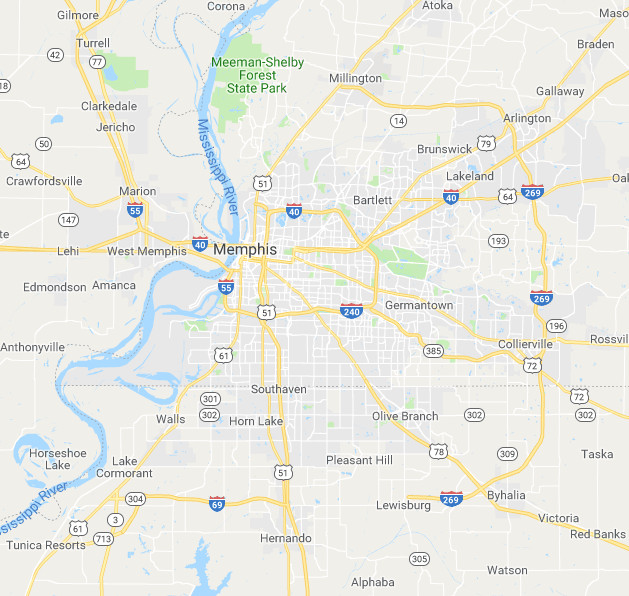
For the end of 2018, we conclude with a post on the nation’s capital.  With the recent announcement of Amazon.com planning to build new headquarters in Crystal City, Virginia, local citizens and officials have questioned whether the transportation system of  Washington, D.C. can handle the increased load on its system.  The D.C. Metro has been criticized for years — with many residents of the area arguing that the iconic subway/local rail system is not far-reaching and comprehensive enough to meet the needs of many commuters.

dc_metro_map

The history of the D.C. Metro is also intertwined with the history of the freeway system in the nation’s capital — namely, that some of the Metro lines were built along corridors where Interstate highways might have run.  Critics might argue that Washington D.C. has the worst of both worlds: an inefficient, incomplete rail system combined with an inefficient, incomplete expressway system.  Whether you commute by car or without a car in D.C., you’re likely to run into hassles and headaches.

DC traffic

If you want to live in Washington D.C., you better get used to a busy commute!


What makes Washington so unique from every other city in the United States, besides being the seat of the federal government?  A lot of it has to do with the transportation system.  Much of the planning for the city’s original layout was borne from the mind of one man, a French military engineer by the name of Pierre L’Enfant (1754-1825).  L’Enfant had a logical plan for the layout of the District of Columbia:  streets that ran north-south would have a number (1st, 2nd, 3rd, etc.) while streets that ran east-west would have a letter (A Street, B Street, etc.).  Streets that ran in a diagonal manner would be christened as as avenue with one of the state names (Pennsylvania Avenue, New York Avenue, etc.)  You can read more details of this plan in a fascinating article at curbed.com here.

All very sound and orderly, but when it came time for Washington, D.C. to come up with its own freeway plan in the mid-1900s, the process was anything but.  Numerous changes and revisions were made, and to this day, much of the D.C. freeway system, especially around the downtown areas, lies in bits and pieces.


District_of_Columbia_1955_Yellow_Book

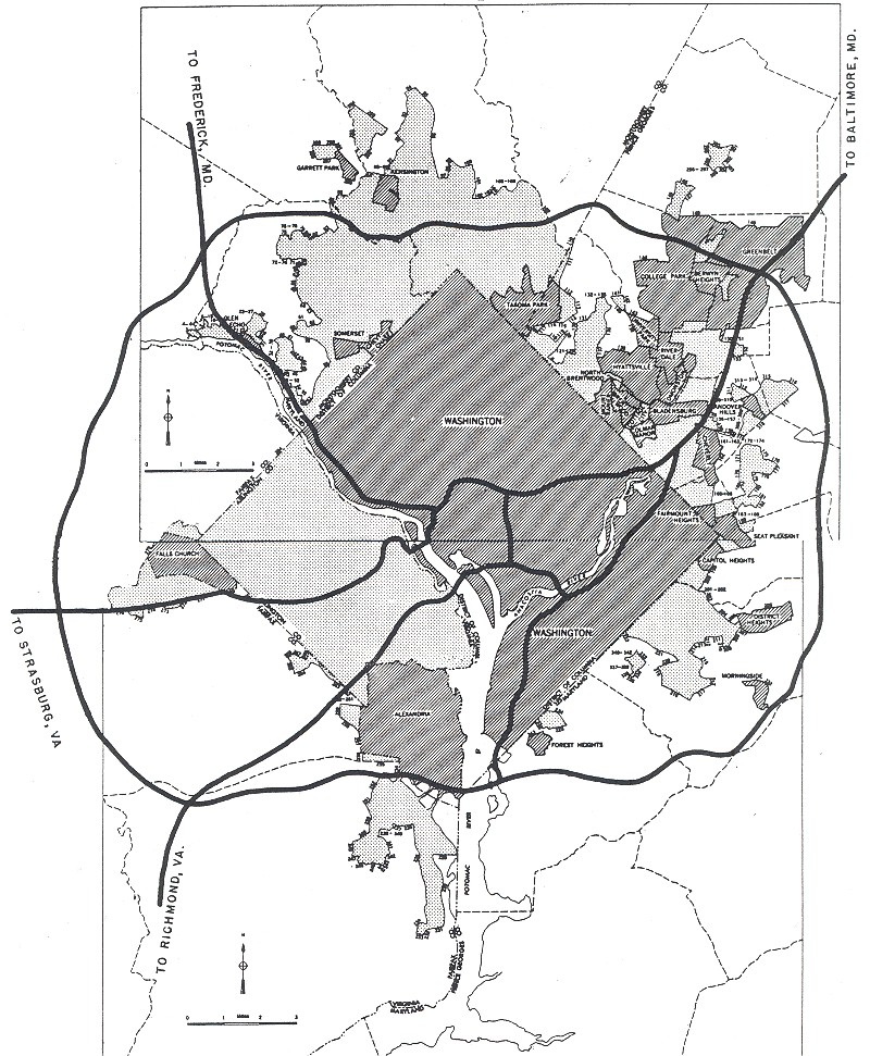
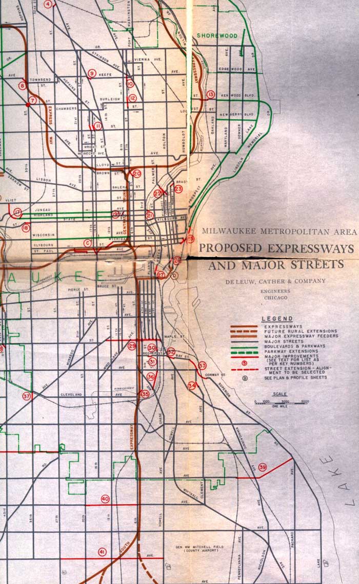
Plans from 1955 Yellow Book
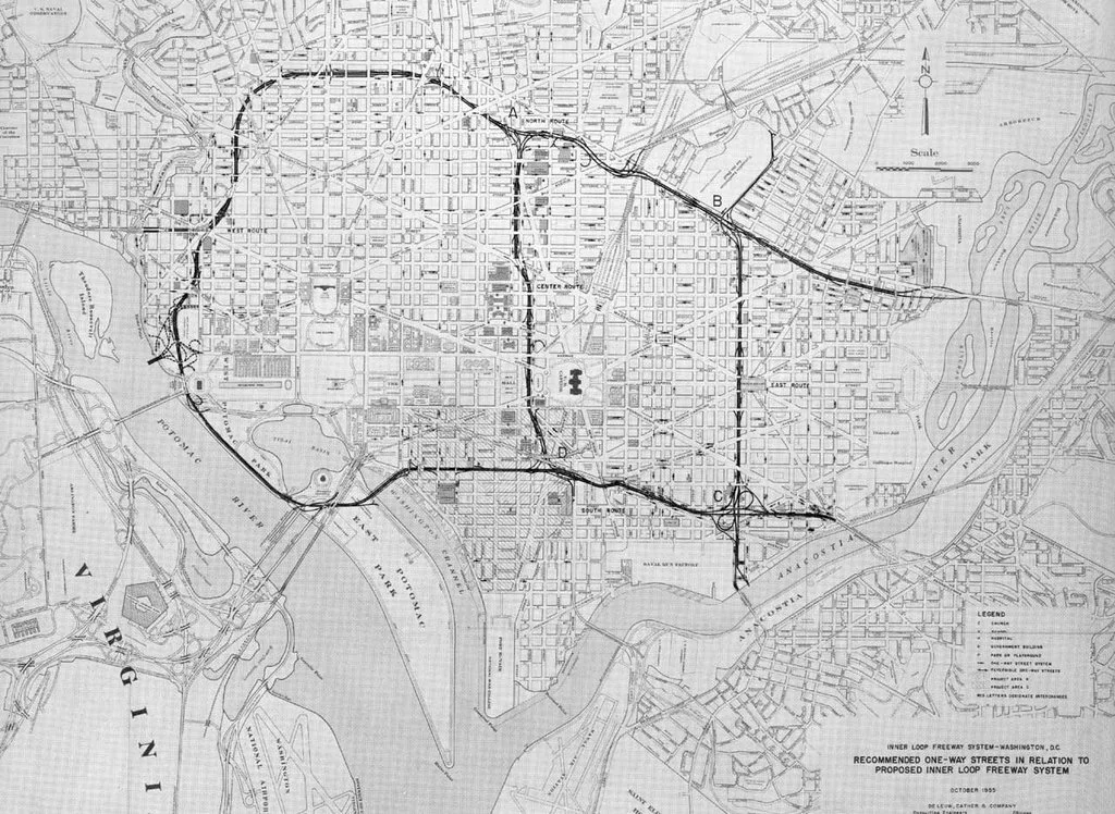
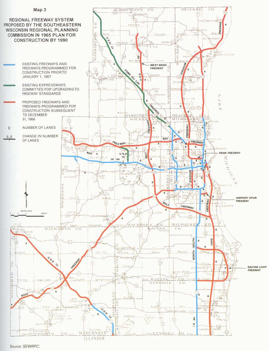
 

Basic Freeway Plan 1958

1958 Plans


DC_Area_Map_XL_1971_plans

1971 Plans


While it isn’t possible to cover all the canceled/altered/abandoned highway projects in one post, here are some of the more notable ones:


I-95:

Currently I-95 runs along the eastern half of the I-495 beltway, but this was not the original plan.  As we saw with I-40 in Memphis, I-95 was to have made a direct cut through the city.  The original plan (coming up from the south) was for I-95 to cross the beltway, travel the entire length of I-395, and then turn northeast, eventually merging with the College Park/I-495 beltway interchange.  The “Northeast Freeway” had several different proposed routes.  The latest one, from the early 1970s, would have had I-95 as an eight-lane freeway running through the North East sector of the city along the Pepco power line and B&O Railroad corridors.  You can see evidence for the continuation of I-95 inside the beltway by the “over-engineered” interchange at College Park, which takes south-bound drivers to a Park and Ride on the Metro Green Line:

Google_Maps_-_2018-12-25_14.24.37


I-70S:

part of the proposed North Central Freeway.  Before 1975, I-270 in Maryland was designated I-70S.  While it currently terminates at the northwest corner of the I-495 beltway in North Bethesda, plans existed to extend the freeway into D.C. itself.  Originally the freeway was to run along the same route as Canal Road and the Clara Barton Parkway before meeting up with I-66.  The proposed route was then changed, with I-70S traveling along the I-495 beltway before turning south near Takoma Park, eventually merging with then-proposed I-95 In the North East part of D.C.  The freeway was to be six lanes and travel parallel with the B&O railroad, with a cleared right-of-way.  Residents of D.C. and Takoma Park stridently and occasionally violently opposed the highway, concerned over proposed demolitions in the Woodside Park and Sligo Creek Park neighborhoods.  The proposed highway was abandoned in the early 1970s.

I-66:

Also known as the North Leg Freeway.  Up until the 1970s, plans existed to extend I-66 eastward by 1 1/2 miles from its current terminus at U.S. 29 and K Street.  I-66 was to have run via tunnel underneath K Street before emerging at ground level to merge with I-95 (currently designated I-395) near New York Avenue.

dc_stage7

Map of the proposed I-66, I-95, and I-295 extensions in the central part of D.C. 

Inner Loop 1280

A slightly modified proposal showing more detail.

I-266: 

Interstate 266 was to have been a short connecting freeway running much of its length along the Potomac River.  The western terminus was supposed to have been where Sprout Run Parkway crosses I-66 in Arlington, Virginia.  From there, I-266 was to run along the current route of Sprout Run, cross over the Potomac along the proposed Three Sisters Bridge, and then turn east, running along Canal Road NW before merging again with I-66 near Rock Creek and Potomac Parkways and K Street.  Strong, and occasionally violent protests against the planned Three Sisters Bridge during the 1960s and 1970s caused the I-266 plan to be abandoned.  The only segment of the proposed freeway to see completion became known as the Whitehurst Freeway (U.S. Route 29), which runs  for approximately 0.8 miles.


I266 three sisters bridge map

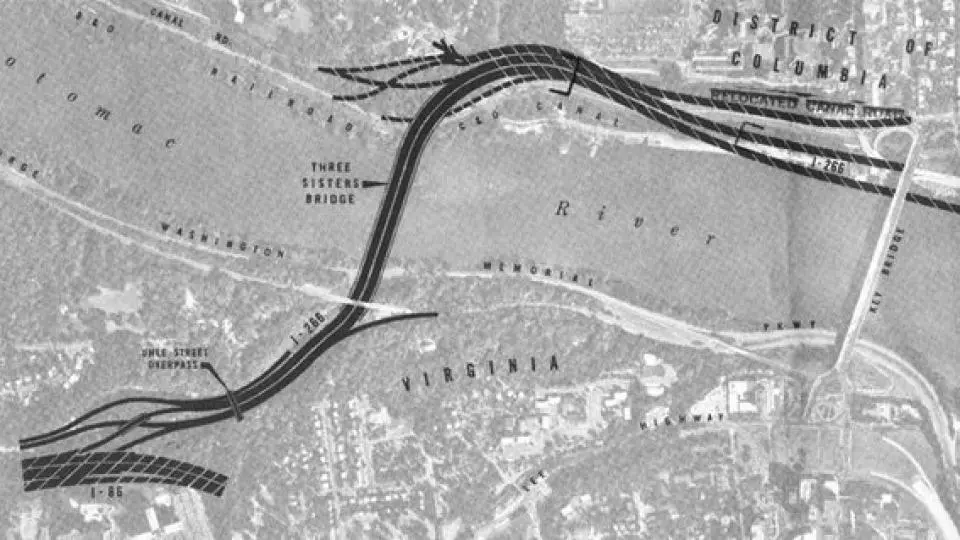
Proposed route for the western segment of I-266.


three sisters bridge

An artistic rendering of the proposed Three Sisters Bridge in Arlington.

I-295:

Also known as the Anacostia Freeway.  Originally intended to follow the route of I-695 and become part of the “Inner Belt” in downtown D.C.  Other proposals had the interstate running along D.C. Route 95.

I-695:

Interstate 695 is only two miles long, but there were plans to extend the highway further east as well as west.  During the 1960s proposals were made to extend I-695 west, which would have brought it in the vicinity of the Washington Monument and Lincoln Memorial along Maine and Independence Avenues, before terminating at I-66 near the Constitution Avenue interchange:

dc-plans


In the 1990s another proposal was made, this time to extend the freeway east along Southeast Boulevard, eventually merging with D.C. Route 295.  The goal was to relieve congestion on the heavily-traveled John Philip Sousa Bridge.


Southeast_Blvd_-_Google_Maps_-_2018-12-25_16.44.28

Southeast Boulevard exiting off to Pennsylvania Avenue.  The highway at left, which runs under the Penn. Avenue overpass to RFK Stadium, was originally intended as an eastern extension of I-695.


I-595:

Interstate 595 was originally conceived as a spur freeway linking I-395 with Reagan National Airport in Arlington.  It was to have followed the same path as current U.S. Highway 1.  The route was never upgraded to Federal Interstate Highway standards.


DC-planned-freeways

Wikimedia map showing some of the various highway proposals for Washington D.C. during the 1950s – 1970s.

With the advent of Amazon.com coming to town, it will be fascinating to watch the city’s debate over transportation continue and what plans will be approved going forward.

Thanks to all you great readers for an exciting journey here in 2018!  Rest assured, there will be much more to post in the new year!


Additional Sources:

https://commons.wikimedia.org/wiki/File:DC_freeway_map.svg

https://www.fhwa.dot.gov/highwayhistory/data/page05.cfm

https://en.wikipedia.org/wiki/Washington_Metro

https://dc.curbed.com/2014/8/13/10061100/facts-and-myths-about-dcs-street-system

http://www.vahighways.com/route-log/i266.htm

https://www.washingtonpost.com/archive/politics/1978/10/30/no-new-freeways-slated-for-district/73617023-5f32-4617-99ae-edf7eab5192a/?utm_term=.ac20df4dc53b

http://wwwtripwithinthebeltway.blogspot.com/2007/03/georgetowns-waterfront-freeway.html

https://en.wikipedia.org/wiki/North_Central_Freeway_(Washington,_D.C.)

https://en.wikipedia.org/wiki/Interstate_270_(Maryland)#History

https://en.wikipedia.org/wiki/Interstate_66#District_of_Columbia_2

https://en.wikipedia.org/wiki/Northeast_Freeway_(Washington,_D.C.)

http://wwwtripwithinthebeltway.blogspot.com/2007/04/1971-dc-b-i-70s-i-270-takoma.html

http://www.fosc.org/NCFreeway.htm

http://www.dcroads.net/roads/southeast/


Short-term Thinking: Indianapolis and the plan for I-165

Traveling out of Chicago into Indiana and down Interstate 65, we now arrive at the Midwestern hub of Indianapolis.  It’s easy to forget that it wasn’t just the big metropolises that faced highway revolts and canceled freeways — as we saw with Winnipeg, plenty of smaller cities had to change their transportation plans as well.  As of November, 2018, Indianapolis is having political debate over what should be done with the I-65/I-70 split north of downtown (AKA “Dead Man’s Curve” due to the high number of fatalities on this stretch), as this particular section of highway nears the end of its 50-year useful life.  How much more interesting (or chaotic?) things might have been if they had thrown another freeway into the  mix!  Yet during the late 1970s, that possibility was considered.

The expressway plan for Indianapolis during the 1960s differed in several ways compared to what was ultimately built:

indianapolis

The original plan for I-65 was to cross the city west of downtown, taking a more due south direction before reaching the I-465 beltway.  I-70 was to cross I-65 to the west of downtown as well.  Apparently, the Indiana Department of Transportation never came up with plans to route I-74 through the city proper, letting the highway utilize the southern and western portions of I-465 instead.   Even more interesting were the original plans for I-69.  Coming from Fort Wayne, I-69 was to have come from a more easterly direction, passing by Lawrence along the current paths of U.S. Route 36 and Massachusetts Avenue, intersecting I-70 at downtown near Woodruff Place.  Later I-69 was re-routed to approach Indianapolis from further north, near Castleton.  These alterations led to the layout for the city we have today:

IN-Indianapolis

Of particular note, upon studying the above map, is the existence of two “sub-standard” freeways in the Indianapolis area: The Airport/Sam Jones Expressway on the city’s southwest side, which connect I-465 and the airport with I-70 — and Shoreland Avenue on the southeast side.  Neither of these highways were ever given a Federal Interstate, U.S. Highway, or Indiana State Route Highway designation, and thus remain unnumbered.

One particular roadblock in the Indianapolis expressway system was the lack of a freeway between the city’s north side and downtown.  Original plans had I-69 advancing further south beyond the I-465 beltway to meet up at the I-65/I-70 split, but this proposal was later abandoned.  Part of the problem had to do with the fact that since I-69 originally ended at I-465 (Exit 0) , extending the freeway further south would require all the exits for I-69 in the state of Indiana to be re-numbered — though, as others point out,  this will likely be done in the near future anyway, since I-69 is already being built in the southwest part of the state as part of the “NAFTA Superhighway.”

In 1978 an alternative to the I-69 extension was proposed: Interstate 165, which would have extended from the north I-65/I-70 split northward to 38th Street.

indianapolis_165

By 1981, however,  there was the question as to whether I-165 needed to be built at all, with some local officials feeling that Indianapolis’s current road network was enough to meet current local needs, and on July 30, 1981, I-165 was withdrawn from Federal Highway Administration plans.  Since then, there have been no plans for any further freeway construction in Indianapolis.  For those of you who live in Indianapolis, you can still see a sign of the proposed I-165 corridor to this day:

I-65_-_Google_Maps_-_2018-11-18_15.34.36

Traveling north on I-65 at the split with I-70.  Notice the “ramp stubs” to the right and left — these were to have been the northbound and southbound lanes for I-165, respectively.


Additional resources:

http://indyroads.com/inhistory.htm

https://www.tripinfo.com/maps/IN-Indianapolis.htm

https://en.wikipedia.org/wiki/Sam_Jones_Expressway

https://en.wikipedia.org/wiki/Interstate_165_(Indiana)

https://www.aaroads.com/forum/index.php?topic=284.125

http://www.kurumi.com/roads/3di/ix65.html#165in

https://www.fhwa.dot.gov/highwayhistory/data/page05.cfm

https://www.urbanophile.com/2016/10/22/were-urban-freeways-a-good-idea/

Waukegan Illinois’s “Road to Nowhere”: the Amstutz Expressway

Back to the United States, with a return to the Chicago metropolitan area.  In the northern suburb of Waukegan, there exists a freeway with very little traffic on it.  A bizarre sight indeed, considering that many suburban expressways in the Chicago suburbs are usually packed with vehicles :

266_Amstutz_Expy_-_Google_Maps_-_2018-10-01_13.59.01

Illinois State Route 137, better known as the Amstutz Expressway in Waukegan, is one of those weird anomalies that appears to defy conventional explanation.  Freeway critics have argued over the years that building freeways increases traffic and congestion.  Yet, for some odd reason, the Amstutz appears to have had the exact opposite effect, proving that the adage “If you build it, they will come” is not always applicable.  How did this happen?

Some Chicagoland residents might be surprised to learn that the history of the Amstutz dates all the way back to the first decade of the 1900s, when there were plans for a “Lakefront Industrial Highway” that would link the factories of Lake Michigan north of Chicago.  With the advent of the freeway-building age in the mid-1900s, plans evolved for a higher-speed corridor.

Poor Melvin E. Amstutz, who was the director of the Lake County Illinois highway department during the 1960s, probably never would have guessed that his name would be used as a joke and source of derision after having a highway named after him.  Yet that is exactly what happened.  The preliminary plan for the Amstutz was to link the northern lakefront suburbs of Chicago, namely North Chicago and Waukegan.  The belief among highway planners at the time was that the expressway could serve as a viable alternative route to I-94 for the residents of the northern suburbs, easing downtown traffic and serving those who worked in the factories near the waterfront.  By 1972 the plan was for the Amstutz to run from the Tri-State Tollway near Northbrook up to the Wisconsin state line.

The project, obviously, didn’t get far off the ground.  Any hopes that an alternative corridor could serve the northern Chicago suburbs came to a halt when construction was stopped in the late 1970s .  Not only did the Amstutz fail to connect the northern suburbs to the Wisconsin state line, it didn’t even fully connect Waukegan to North Chicago.  Only two small segments of the highway made it through to completion: the North Chicago segment runs parallel to Sheridan Road from Buckley Road to Martin Luther King Jr. Boulevard (1.3 miles), while the Waukegan segment starts near Genesee Street and travels north to Greenwood Avenue.  At that point State Route 137 jogs west before connecting back to Sheridan Road (2.9 miles).

Waukegan1a

The circled areas on the map represent the approximate areas where the Amstutz Expressway was built to completion.

Amstutz Expy Google Maps

At the northern terminus of the Amstutz, near Greenwood Avenue.  Note the extra-wide median, road stubs, and underpass on the left side — this indicated that the freeway was originally planned to extend further north.

Although discussion continued into the early 1980s about completing the Amstutz, there was also recognition that the areas the freeway was supposed to serve were in decline.  Although Waukegan’s population remained stable, many of the factories along the expressway closed down, part of a nationwide trend in the decline of manufacturing.  As a result, fewer than 15,000 vehicles travel the highway daily.

In the years since, calls have been made by area residents to tear down the Amstutz in order to revive the lakefront district with new housing and commerce.  In 2015, journalist David Rutter went so far as to call the expressway “a massive purple wart” on the city of Waukegan.  “There’s nothing about the 2.9-mile abomination and its social, financial, aesthetic or cultural contribution to Waukegan that could not be improved by unleashing jackhammers to destroy it,” he wrote.

In spite of the calls to tear it down, the Amstutz Expressway has managed to find at least two other uses over the years.  The freeway has been a popular shooting scene for multiple movies, including “Blues Brothers”, “Groundhog Day”, “Ordinary People”, “Planes, Trains, and Automobiles” and “Batman Begins”. The City of Waukegan, Waukegan Bike Project, and Waukegan Main Street have also sponsored several “Bike the Amstutz” festivals, where cyclists can bike the entire length of the freeway for one day, as well as enjoying live music, artwork, games, and prizes.  Who says freeways only have one use?

ct-lns-rutter-amstutz-response-st-0814-20150813

A snapshot of 2015’s “Bike the Amstutz”.  Image from The Chicago Tribune.

Additional sources:

http://www.openstreetmap.org

maps.google.com

https://newspaperarchive.com/daily-herald-suburban-chicago-aug-16-1972-p-56/

http://www.chicagotribune.com/suburbs/lake-county-news-sun/opinion/ct-lns-rutter-amstutz-st-0731-20150730-story.html

http://www.chicagotribune.com/news/ct-xpm-1998-05-17-9805170231-story.html

https://roadnow.com/us/wi/road_description.php?road=Wisconsin-Highway-794&id=r10012077

https://en.wikipedia.org/wiki/Illinois_Route_137

https://www.aaroads.com/blog/melvin-amstutz/

https://www.aaroads.com/forum/index.php?topic=8467.0

Nothing to See Here: Winnipeg, Manitoba

For this post we journey to the north to pay a visit to our Canadian friends.  Don’t let the title fool you: there is actually a lot to see and do in the city of Winnipeg, Manitoba: there’s The Forks, the city’s riverside shopping and dining compex.  Just north of there is the Canadian Museum of Human Rights.  Assiniboine Park hosts the city’s zoo, a large botanical garden, outdoor theatre, and summer music festival.  There’s also tours for the majestic Manitoba Legislative Building. Many art galleries, parks and gardens, and other historic sites dot the city.

No, the phrase “nothing to see here” is referring to something else entirely.  Have a look at Winnipeg’s city map, courtesy of ontheworldmap.com, and tell me what’s missing:


winnipeg-area-map-max.jpg

No freeways here, apparently (well, not exactly true.  Read on for more details).  The Winnipeg metro area is home to nearly 800,000 people, and yet there appears to be no expressway system criss-crossing the city.  Larger Canadian cities  like Toronto, Ottawa, and Montreal have extensive freeway networks.  Even cities closer to Winnipeg’s size, such as Hamilton and Edmonton, have more limited-access highways.  Yet Winnipeg, along with Vancouver in British Columbia, appear to have been unaffected by the freeway-building craze that dominated the 20th century.  How did that happen?

Let’s rewind back to the late 1950s.  Back at the time, the city of Winnipeg brought in United States traffic engineer Wilbur Smith, who hailed from New Haven, Connecticut.  Smith’s goal was to tackle the transport issues that Winnipeg was facing, including downtown parking and heavy urban traffic.  One of his proposals was to build a loop freeway around Winnipeg’s downtown district:

winnipeg - central freeway

The proposed Central District Expressway was to skirt the downtown business district, with interchanges at Provencher Boulevard, St. Mary’s Road, Higgins Avenue, Logan Avenue, Water Avenue, and the Pembina Highway, along with several others.

A few years later, the two men who headed Winnipeg’s  Metro Planning Division, George Rich and Boris Hryhorczuk,  decided to survey the citizens of Winnipeg to find out more about their daily travel and commuting habits.  Their research culminated in the W.A.T.S. (Winnipeg Area Transport Study) recommendations of 1968.  The proposal was for Winnipeg to include five “radial” freeways, along with a “Suburban Beltway” that was to run a few kilometers inside the Perimeter Highway.  The plan was to have Winnipeg’s proposed freeway system completed by 1991.

winnipeg freeway plan - half

Proposed freeway plan for Winnipeg.  The dotted green line represents the proposed Suburban Beltway, while the dotted reddish-purple lines include the Northern, Southern, Western, Eastern, and Southeastern freeways.

The 1970s saw major public opposition to the proposed network.  In 1980 city planners tried to include funds in the city’s budget to build part of the Northern freeway, but were unsuccessful.  Although many urban advocates praise Winnipeg’s lack of urban expressways, some in the city wonder whether the issue should be re-opened for further debate.

One tiny remnant of the city’s freeway plan did make it through to completion, however:  a small section of Winnipeg Route 42 right outside of downtown, the Benjamin Disraeli Freeway, which stretches for a little over a mile.

Disraeli_Fwy_-_Google_Maps_-_2018-09-16_22.28.00

Facing north on the Disraeli Freeway, near the Sutherland Avenue exit.


Additional sources:

https://www.revolvy.com/page/Winnipeg-Area-Transportation-Study

https://www.flickr.com/photos/manitobamaps/sets/

https://www.winnipegfreepress.com/local/driven-to-great-heights-427718613.html

https://macsphere.mcmaster.ca/bitstream/11375/12753/1/fulltext.pdf

Beverly Hills: That’s Where I Want a Freeway To Be?

Even the band Weezer probably couldn’t make a hit song out of that…..

For some odd reason, a lot of “disaster” movies take place in  Los Angeles, California. Why is that? Does it have to do with the city’s warm and sometimes unpredictable climate?  Does the huge sprawling landscape of land and people of the area create a sense that bad things are more likely to happen there?  Or is it because that Hollywood and the film studios are there, and therefore it’s probably more convenient and less costly to shoot on location?  Who knows?

The transportation system of Los Angeles, while certainly not a disaster, can lend itself to a certain level of madness and chaos at times.  Negotiating the thoroughfares of the L.A. area must feel like trying to find your way through  a giant maze: according to L.A. Almanac, the California megalopolis has over 300 miles of federal Interstate highways, 200 miles of other freeways/expressways, and 2000 miles of principal arterial roadways.  Even all that isn’t enough to deal with the crazy backups and congestion! What people who live in the City of Angels may not realize, however, is that L.A. doesn’t even crack the “Top Ten” of cities with the longest commute times.  People in New York City, Chicago, Washington, Baltimore, and Atlanta actually take longer to get to work.  Cold comfort (or, since we’re in California, warm comfort?) to the residents of the second -largest city in the United States.

Designing a transport system for 18 million people is no small feat, especially when those 18 million likely have 18 million different destinations to get to!  As a result, Los Angeles is fairly unique in that it has several spots where multiple freeways come together, including the “East L.A. Interchange” just southeast of downtown, where the I-5, I-10, U.S. 101, and State Route 60 freeways all come together in a  rather dizzying manner.

12596672_H8x4qf03SFzduJTtNHWy-_QKo7FiSsIVwDvxj9ggQW8

Make sure you’re in the correct lane!

A bit of clarification is in order here.  Why is it that, here in the United States, certain freeways have a Federal Interstate designation, others have a U.S. Highway designation, and yet others have  a State Route designation?  Hopefully I can get into more detail in a future post, but the answer primarily revolves around funding and maintenance — U.S. highways are primarily funded by Congress, and state routes are primarily funded by the state legislatures.  More on that later…..

Anyhow, as impressive as all this is, it might be interesting to point out how much more grandiose the expressway system might have turned out for Los Angeles if the planners of the 1950s and 1960s had turned their California dreamin’ into reality.  The L.A. Times has a neat interactive graphic that shows the freeways that were planned but never built, shaded in red:

unbilt-la-freeways


Lookie, lookie, what do we have here?

la-me-aa2-snapshot-failed-freeways-20141029

A freeway running through Beverly Hills, California?  Say it ain’t so! (with apologies again to Weezer….)  The story of the Beverly Hills Freeway actually goes back a few years earlier, as this map from 1943 shows:

1943 - REPORTS - Freeways For The Region

As you can see from the above, the freeway that was to run through Beverly Hills (the “Santa Monica Parkway”) would have connected the 405 ( then proposed as the “Sepulveda Parkway”) with U.S. 101 (then proposed as the “Hollywood Parkway”).  Beginning at its western terminus from the edge of the Pacific Coast, the freeway was to run northeast, parallel with Santa Monica Boulevard, crossing over Wilshire Boulevard, and then turning east, straddling a path between Beverly and Wilshire before reaching its eastern terminus just east of the 101.

Why Beverly Hills, though, of all places?  As we’ve seen with the Clark Freeway in Cleveland, it wasn’t just low-income communities that were affected by the interstate highway craze of the 1950s and 1960s — affluent neighborhoods also discovered that their prized homes were in line for the bulldozer as well.  There actually was a certain logic to the highway also, which would have connected the Santa Monica Pier and Venice Beach on the coast with the Hollywood district.  Last but not least, it is important to remember that back in the 1940s, Beverly Hills was actually a well-off but sleepy “bedroom community” of Los Angeles — it would be a couple decades before it became associated as the place of lavish wealth that people know it as today.

The same fate awaited the Beverly Hills Freeway as countless other highway projects during the 1960s, with local opposition stopping the plan in its tracks.  Also of note is that since the freeway was a state route instead of a Federal Interstate, the city of Los Angeles was unable to access federal funds in order to complete the project, which had a projected price tag of $300 million.  By 1975 the freeway through Beverly Hills was no longer on the drawing board.

Currently there are no signs of what was to become the proposed Beverly Hills Freeway, save for one: for travelers on the 101, there is a stretch between Melrose Avenue and Silver Lake Boulevard where the freeway has an inexplicably wide median.  That’s no mistake: the median was built that way to accommodate what would have been on-ramps and off-ramps to the canceled freeway.  There are no longer any plans for an “express way” to Beverly Hills — you might as well take Melrose or Wilshire and enjoy the scenery, even if it takes you longer to get there!

Hollywood_Fwy_-_Google_Maps_-_2018-08-16_14.58.20

U.S. 101 near Vermont Avenue, where the Beverly Hills Freeway would likely have intersected.

Additional sources:

http://maps.google.com

See You In Court: Memphis and the Fight Over Interstate 40

The beautiful city of Memphis, Tennessee is known for many things:  stronghold of the Civil Right Movement.  Home to Elvis Presley and Graceland.  A rich artistic culture that helped launch the careers of many musicians, including B.B. King, Johnny Cash, Carl Perkins, and Jerry Lee Lewis.  And who can say “no” to Memphis’s world-famous barbecue?

Memphis is also known for something else: an ugly and drawn-out battle over one of the most controversial highway projects in United States history, which would eventually wind up at the United States Supreme Court in the case of Citizens to Preserve Overton Park v. Volpe.  How could an argument over a highway wind up being debated at the highest court in the nation?

In order to answer that question, let’s turn to the freeway plans for the city, which date back to the early 1960s.  Compared to a lot of other cities its size, Memphis seemed pretty cut-and-dry.  Interstate 55 would skirt the southwestern part of the city.,  Interstate 240 would be the primary by-pass around the area.  The only other major highway planned was Interstate 40, which would neatly cut a straightforward east-west path through the city proper.  Pretty simple, right?


tennessee_memphis_1976

Zoom in a little closer, however, and you realize that a potential headache is brewing:

overton park 2

Yup, that’s I-40 planning to cut right through Overton Park.  For those of you unfamiliar with the Memphis area, Overton Park is one of the scenic jewels of the city, consisting of over 340 acres that includes a 9-hole golf course, the Memphis Zoo, the Memphis College of Arts, a 126-acre nature preserve area, and the Levitt Shell amphitheater.


links at overton park

View of The Links at  Overton Park, the main golf course


OvertonPark_Greensward

Another view of the park, this time from the historic Greensward area

So how did this all come about?  To find out, let’s go back a few years.  The plan to build Interstate 40 through Overton Park began in 1956, at the suggestion of Memphis city officials and the Federal Highway Administration.  One year later, a group of dedicated city residents decided to form the “Citizens to Preserve Overton Park,” and a years-long battle ensued.  Why were government officials so keen on routing high-speed expressways through tranquil park lands?  On the surface, the idea might sound ludicrous, but according to Josh Whitehead at Creme de Memphis, the reason was actually pretty simple:

“Parks were viewed by the federal and state highway agencies as ideal locations for interstate highways through urban areas in the 1950s and 60s because no condemnation was required. This changed when Congress passed the Department of Transportation Act of 1966, which contained Section 4(f) requiring a finding by the highway agencies that there was no reasonable and prudent alignment outside of the public park or land.”

Of course, it wasn’t lost on the Citizens to Preserve Overton Park (CPOP) that there would be significant environmental consequences to the freeway– *ahem*– I mean, expressway project (I just found out that Tennessee refers to all “freeways” as “expressways” due to the fact that there are no Interstate toll roads in the state).  The list of possible negative effects included destruction of Rainbow Lake and some of the old forest area within the park, alongside the fact that I-40 would split the entire park in half, making it more cumbersome for pedestrians to get around:

overton park3

During the 1960s alternatives were proposed, including routing I-40 north of the park, but this proved costly and redundant since the northerly route brought the highway within a couple miles of the I-240 bypass.  Tensions within Memphis reached a new high on April 4, 1968, when Martin Luther King Jr. was assassinated while standing outside at the city’s Lorraine Motel.  Interestingly enough on that same day, the city council voted and gave the green light to allow the construction of I-40 through Overton Park.  In 1969 CPOP lost a lawsuit filed against the city to halt construction.  In 1970 an appeal was made to the 6th Circuit Court, where CPOP lost again.  Finally, in 1971, CPOP won the right to have their case heard at the U.S. Supreme Court.

With CPOP bringing their case to the highest court in the country, John Volpe, who at the time was Secretary of Transportation under President Richard Nixon, represented the respondent in the case.  CPOP’s main argument to the court was summarized thus:

“Under § 4(f) of the Department of Transportation Act of 1966 and § 138 of the Federal-Aid Highway Act of 1968, the Secretary of Transportation may not authorize use of federal funds to finance construction of highways through public parks if a ‘feasible and prudent’ alternative route exists. If no such route is available, he may approve construction only if there has been ‘all possible planning to minimize harm’ to the park. Petitioners contend that the Secretary has violated these statutes by authorizing a six-lane interstate highway through a Memphis public park. In April 1968 the Secretary announced that he agreed with the local officials that the highway go through the park; in September 1969 the State acquired the right-of-way inside the park; and in November 1969 the Secretary announced final approval, including the design, of the road. Neither announcement of the Secretary was accompanied by factual findings.”


For their part, Volpe and his allies made the following counter-arguments:

“[T]he requirement that there be no other ‘prudent’ route requires the Secretary to engage in a wide-ranging balancing of competing interests. They contend that the Secretary should weigh the detriment resulting from the destruction of parkland against the cost of other routes, safety considerations, and other factors, and determine on the basis of the importance that he attaches to these other factors whether, on balance, alternative feasible routes would be ‘prudent.’

But no such wide-ranging endeavor was intended. It is obvious that in most cases considerations of cost, directness of route, and community disruption will indicate that parkland should be used for highway construction whenever possible. Although it may be necessary to transfer funds from one jurisdiction to another, 25 there will always be a smaller outlay required from the public purse 26 when parkland is used since the public already owns the land and there will be no need to pay for right-of-way. And since people do not live or work in parks, if a highway is built on parkland no one will have to leave his home or give up his business. Such factors are common to substantially all highway construction.”

The Supreme Court decided in favor of CPOP, but that didn’t end the saga.  Throughout the 1970s, plans were discussed to route I-40 underground through the park, but again, cost considerations prevented this idea from gaining traction.  Finally, in 1981, the Department of Transportation removed the I-40 designation from the “orphaned” section of I-40 that had already been completed inside the I-240 beltway.  This part was re-named as Sam Cooper Boulevard.

Sam_Cooper_Blvd_-_Google_Maps_-_2018-06-13_00.59.18

Sam Cooper Boulevard, facing west near East Parkway, with Overton Park in the distance.

Further changes were made to Memphis’s interstate system in the years following Citizens to Preserve Overton Park v. Volpe.  I-40 was officially routed on the northern section of the I-240 bypass, and the I-240 designation was eventually removed.  The southwestern part of I-240 has also been re-designated as I-69 — known by its nickname as “The NAFTA Superhighway” — which has also generated a large amount of controversy in its own right to the present day.   And then there is the current construction of the I-269 outerbelt in the suburban Memphis area, which has raised environmental concerns as well.  The battles continue….


Google_Maps_-_2018-06-13_01.14.04

Map of Memphis Interstates and other major highways, as of June 2018

Additional Sources:

http://cremedememph.blogspot.com/2016/04/overton-park-exwy.html

https://www.overtonpark.org/

http://www.overtonparkforever.org/2011/03/forty-years-ago.html

https://www.law.cornell.edu/supremecourt/text/401/402

http://maps.google.com

https://www.memphisflyer.com/memphis/bumps-in-the-road/Content?oid=3326638

Cleveland’s Clark Freeway: The Mistake on the Shaker Lakes?

Hard as it may be to imagine, there was a time when Cleveland, Ohio was one of the largest cities in the entire United States.  According to the 1920 census, Cleveland was ranked number 5 in population, right behind New York, Chicago, Philadelphia, and Detroit.  By 1970 it had slipped in rankings to number 10, but by that point in time it still had 750,000 people living in the city proper.  Today, in 2018, the city is home to only 388,000, though the metropolitan area still boasts a fairly sizable 2 million.

It comes as no surprise, then, that during the mid-20th century, when the area was a lot more crowded, that there were plans for numerous expressways to cross the area.  Contrast with what Cleveland’s freeway system looks like today:

83 clev

with the original plans from 1944:

clefwy44

During the 1950s and 1960s, the freeway plan for Cleveland underwent numerous revisions.  One plan from the mid 1960s was considerably more ambitious in scope:

Route_location_studies_Clark_Freeway,_East_55th_Street_to_Outer_Belt_East_Freeway_Northeast_Ohio_s_Urban_Infrastructure_-_2018-04-11_23.29.33


The “freeway revolts” that had begun out west during the late 1950s and early 1960s — including the fight against San Francisco’s Embarcadero freeway — eventually spread to the eastern cities a few years later.  As a result, Cleveland’s freeway system sat with multiple gaps and pieces marking uncompleted highways.  Until the mid-1980s, traffic traveling on I-480 had to make use of Brookpark Road between much of the area between I-71 and I-77.  The Jennings Freeway (Ohio State Route 176 between I-71 and I-480) sat in limbo for many years before being finished in 1998.  The only segment of the Parma Freeway to see completion was the northbound exit off I-71 to Denison Avenue.

The saga over the Clark Freeway played out throughout the 1960s.  The original plan for the Clark was to connect I-90 and I-71 near downtown with I-271 (“The Outerbelt”) in the eastern suburbs.  The proposed freeway, which was originally to be designated as I-290, was to run in a straight east-west line through the eastern part of the city and the suburbs of Shaker Heights and Cleveland Heights, as the above map shows with the black line.  Many residents of the two suburbs were particularly aghast at the prospect of having their communities carved up not only by the Clark but also the proposed Heights and Lee Freeways, which were later canceled.  Of particular concern was the probability that the elevated 8-lane Clark  would have a negative environmental impact on the  Shaker Lakes Nature Preserve,  which included Horseshoe Lake:

Horsehoe Lake

The fight against the Clark reached a peak in 1969.  Ohio Governor Jim Rhodes, known for his pro-highway stance and lack of interest in environmental issues, had been pushing for construction of the Clark, fearing the loss of federal funding for the state.  Residents of Cleveland Heights and Shaker Heights, who had already formed committees to block the highway, found an ally in Cleveland Mayor Carl Stokes.  If there was one concern that the city shared with the eastern inner suburbs, it was the potential loss of residents and economic activity to Cleveland’s more distant suburbs.  Rhodes, who was planning to run for the U.S. Senate, realized that he needed the support of Cleveland’s inner suburbs if we was to achieve victory.  An additional factor that played a major role in stopping the Clark was local newspaper editor Harry Volk, who kept the issue alive every week in the area papers, discussing the negative impacts future freeway construction would cause.    By 1970, the plan to construct the Clark through Shaker Heights and Cleveland Heights was pretty much dead.

That, however, was not the final end of the story.  Years later, a portion of the Clark Freeway WAS completed and opened to traffic in 1990, with the designation of Interstate 490.  The 2 1/2 mile highway runs from its western terminus at its intersection with I-90, I-71, and the Jennings Freeway to its eastern terminus at East 55th Street.

I-490_-_Google_Maps_-_2018-05-13_16.56.22

Near the western terminus of I-490/Clark Freeway, facing west.


I-490_-_Google_Maps_-_2018-05-13_16.58.43 
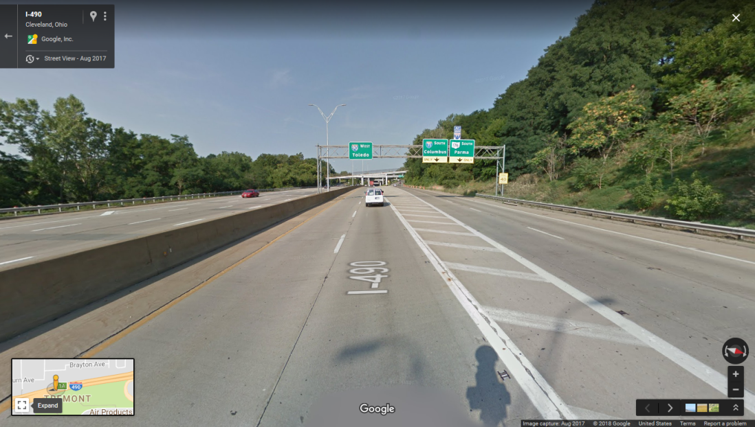
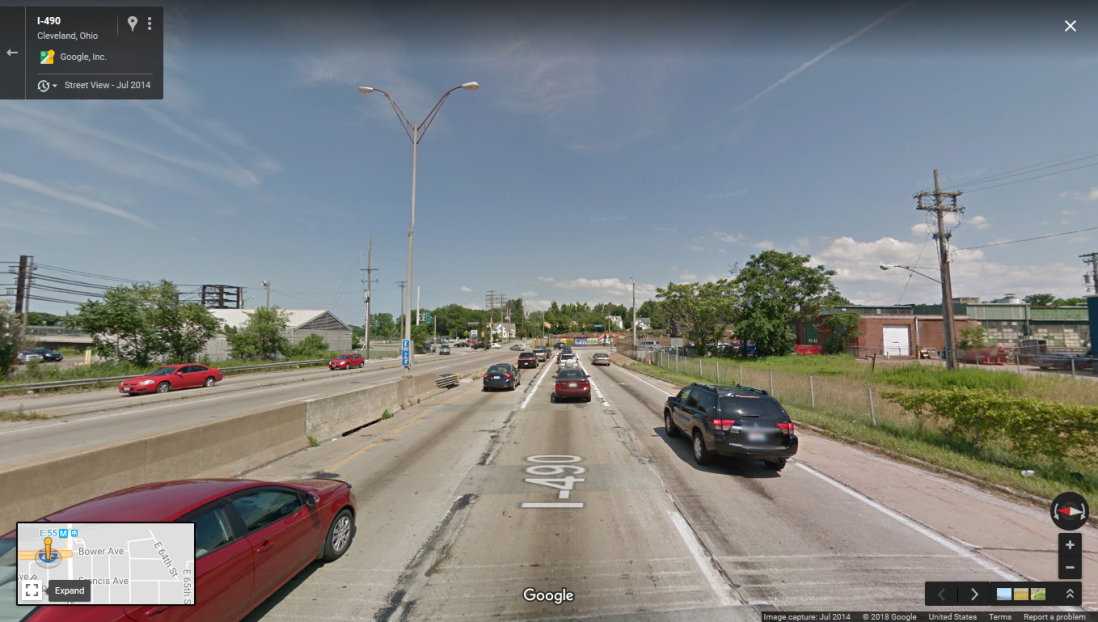
At the eastern terminus of I-490 and East 55th Street.  As of 2018 there are no plans to extend the freeway further east.

Additional sources:

http://maps.google.com

http://www.gcbl.org/blog/2015/02/clevelands-1969-highway-revolt-sheds-light-on-opportunity-corridor

http://www.clevelandmemory.org/freeways/index.html

https://www.interstate-guide.com/i-490_oh.html

http://chuh.net/chhistory/features/freeways.html

St. Paul, Minnesota: The Curious Case of Ayd Mill Road

The twin cities of Minneapolis and St. Paul, Minnesota have enough examples of canceled and altered highway projects that it would be enough to merit a whole series in its own right.  Yet one in particular stands out: the anomaly known as Ayd Mill Road in St. Paul, which meanders through the west-central part of the city, from Selby Avenue near Concordia University to its southern terminus at I-35E near Jefferson Avenue.  One might ask if Ayd Mill is a standard road, a parkway, or a freeway?  The correct answer might be that it’s a little of all of these, and the debate rages on over what it should be for the future.

AydMill

Traveling east on Selby Ave. in St. Paul, one is greeted by the northern end of Ayd Mill with an on-ramp and a small sign at the split-off.  Easy to miss if you’re not really paying attention to your surroundings:

Ayd_Mill_Rd_-_Google_Maps

1484_Ayd_Mill_Rd_-_Google_Maps_-_2018-04-01_16.59.26

From there Ayd Mill travels at ground level through several St. Paul neighborhoods.  The speed limit on the highway is 45mph.  What’s unusual about this road is the weird mixture of off-ramps and stoplights that juxtapose its various intersections.


Ayd_Mill_Rd_-_Google_Maps_-_2018-04-01_17.07.47

Ayd Mill near Hamline Avenue.  Southbound traffic exits to Hamline via the off-ramp, while northbound traffic waits at the stoplight to turn.


Ayd_Mill_Rd_-_Google_Maps_-_2018-04-01_17.16.48

Traveling southbound, near the southern terminus.  Right lane exits off to Jefferson Avenue, with left lanes eventually merging onto I-35E southbound.

So what is the history behind Ayd Mill Road?  In the 1880s, Ayd Mill was originally a stream bed before Chicago, Milwaukee, St. Paul and Pacific Railroad bought up the right-of-way.  Commuter trains used the route to ferry passengers back and forth between St. Paul Union Depot and the Milwaukee Road Depot in St. Paul’s twin city of Minneapolis.

After the railway fell into disuse, the city of St. Paul began construction on the Short Line Road (the original name of Ayd Mill) in the 1960s in an attempt to link I-35E with I-94.  The route was to allow easy travel from commuters in the south suburbs of St. Paul to reach Minneapolis without having to go through downtown St. Paul.  However, opposition to the proposed plan in the Summit Hill and Merriam Park neighborhoods kept this dream from becoming a reality.  It wasn’t until 2004 that Ayd Mill was extended south to make a connection to I-35E.  To this day, Ayd Mill continues to generate discussion and arguments in the Twin Cities.  Should the road be extended further north to link to I-94?  Should it be upgraded to a full expressway?  Should it be converted to a “linear park” with fuller access for bicycles and pedestrians?  The debate continues….

Other sources:

http://www.steve-riner.com/mnhighways/other_rtes.htm

http://maps.google.com

https://www.smart-trips.org/brief-history-ayd-mill-road/

https://en.wikipedia.org/wiki/Ayd_Mill_Road

Just a Little Bit: Milwaukee’s Park Freeway

San Francisco is not the only city in the United States to have ever torn down a freeway.  Milwaukee would follow in its footsteps a few years later.  During the mid-20th century, Milwaukee also had its plans for a sprawling expressway network, linking the city with its disparate suburban communities.

The original plan from 1949 looked a little different compared to the system Milwaukeeans know today:

prop_expwy_sys_1949


The 1965 plan from the Southeastern Wisconsin Regional Planning Committee, which was considerably more ambitious, shows just how much more might I have been done to the area:

m03_1965proposed1990system

One of these crucial highway links in this sprawling system was known as the Park Freeway.  The Park Freeway’s eastern terminus was to start in downtown by splitting off from the Lake Freeway (I-794) near Clybourn and Van Buren Streets, traveling north before turning west and running more-or-less concurrent with Juneau Avenue before making a northwest turn along State Route 145 near the Lake Freeway (I-43).  From there the freeway was to turn west near West North Avenue and 21st Street before reaching its western terminus at what was to be the north end of the Stadium Freeway near North and Lisbon.

Opposition to the Park was almost immediate.  During the mid to late 1960s, community meetings throughout Milwaukee had many residents from the city’s north side neighborhoods speaking out against the construction of the freeway, though a few spoke out in favor.  Also of concern was the environmental impact the freeway would have on Juneau Park downtown, where the merger with the Lake Freeway was planned.  Complicating matters was the fact that the right-of-way for the entire freeway had  been purchased by the city, with many homes and commercial businesses already having been demolished to make way for the new highway.  Residents on the city’s north side complained of being mistreated while they were being evicted from their soon-to-be-razed homes, which included the substandard conditions of the replacement housing they were being offered.

park-west-right-of-way-1970s

View of the cleared right-of-way on the north side of Milwaukee

Opponents of the freeway successfully utilized the newly-enacted National Environmental  Protection Act to halt construction of the freeway in 1972.  By that time, only 0.8 miles of the freeway had actually been completed, the segment from the I-43 junction east to Jefferson Avenue.  A referendum was put on the ballot in 1974 to “close the loop” of the Park with a northern-extended Lake Freeway, along with several other highway projects in the city.

I345-image003.jpg-teardown

Although the referendum passed, freeway opponents were successful in stalling construction through a series of political maneuvers, and by 1980 the plan to continue construction of  the Park was more or less dead.  For the next 20 years, the constructed part of the Park East sat in limbo.  The only completed and opened segment of the freeway was underutilized and did little to bring traffic into the downtown area.


ParkEastEmpty

One of the most consequential figures in Milwaukee’s political scene took the stage as the city’s mayor in 1988.  John O. Norquist came to power on a strong anti-freeway platform.  Norquist was successful in his efforts not only in halting any additional construction to the city’s freeway system, but was eventually able to have the Park East torn down, which began in 2001:


illus_parkeast_demo


park-east3

View of downtown looking west after demolition of the Park East Freeway.


Since demolition was completed in 2002, the  of rebuilding and revitalization of downtown Milwaukee left empty by the tearing down of the Park has been an ongoing process.  Today, many new housing and commercial projects have taken the place where the freeway once stood:


Additional Sources:

http://www.wikipedia.org

http://www.preservenet.com

http://www.wisconsinhighways.org

http://www.onmilwaukee.com

http://city.milwaukee.gov

Against All Odds: San Francisco’s Embarcadero Freeway

Few highway projects in the United States have inflamed as many passions and resulted in as volatile a politics as much as San Francisco’s much-hated Embarcadero Freeway — and yet, for 35 years, the freeway stood in spite of the opposition that dominated throughout its history.

1024x1024

Construction of the Embarcadero Freeway, circa 1956.  Note the clock tower on the World Trade Ferry Building in the background.


First, a little historical background: in the immediate period following World War II, every major American city was focused on the future, which included construction of a series of high-speed expressways to connect different parts of the city, so that traveling across a major metropolitan area could be accomplished in minutes instead of the hours it could sometimes take.  San Francisco, like every other city, had plans for a sprawling freeway system that would connect multiple areas of the city together in a web of arterials and interchanges.  One of these links was to construct a freeway that would link the Bay Bridge on the city’s east side with the Golden Gate Bridge in the northwest.  The proposed highway, Interstate 480 (later downgraded to State Route 480 after 1965), was to run along the Embarcadero up until Bay Street (the “Embarcadero Freeway”), at which point the freeway was to turn west, running parallel to Lombard Street before turning northwest to Doyle Drive as it approached the Presidio and the Golden Gate Bridge (the “Golden Gate Freeway”).

kmap-sf-1951

From the beginning the project was mired in controversy and dissent.  Opponents harshly criticized the double-decker freeway for obstructing the view of the San Francisco Bay and the World Trade Ferry Building, one of only a few historical buildings to have survived the city’s  1906 earthquake and subsequent fire.  Also of concern was the probability that the freeway would wreck the natural beauty of the Telegraph Hill neighborhood.  The San Francisco Chronicle took a particularly harsh tone in one of their 1959 editorials:

“We oppose and have consistently opposed the hideous monstrosity which the State Highway Commission built along the Embarcadero in front of the Ferry Building, obscuring the tower and the World Trade Center from view. … Such an evil is the Embarcadero Freeway, which as we said last Friday and here repeat, should be demolished.”

Although initial construction happened at a rapid pace during the mid-1950s, opposition to the Embarcadero Freeway grew strong enough that further construction was halted in January 1959.  Although there were plans to resume construction in 1964, a major protest attended by 200,000 people in Golden Gate Park to protest further freeway construction  within the city dissuaded California transportation officials from embarking any further on the project.


Embarcadero_Freeway_mid-1950s_AAB-3553

View of “The Stub”, the point at which construction of the freeway was halted, near Broadway.  Note the metal barriers to prevent errant cars from diving over the edge.

In the following years, calls were made to tear down the portion of the Embarcadero Freeway that had already been constructed.  In 1987, a citywide referendum to tear the freeway down was defeated by a nearly 2-1 margin.  Interestingly enough, the greatest opposition to demolishing the freeway came from the city’s Chinatown neighborhood, who feared the loss of an easy-access corridor between the Bay Bridge and their district would have a severely negative effect on business.

rawImage

Another view of the freeway, facing north near Howard Street.

All this changed on October 17, 1989.  The Loma Prieta earthquake did significant damage to the transport system of the Bay Area, including 42 fatalities as a result of the collapse of the double-decker I-880/Cypress Viaduct in Oakland.  While the Embarcadero Freeway did not collapse, the structural damage was enough for the city to close the freeway due to safety concerns.  Discussion began as to what to do next.


EMBARCADERO-1990-DF
Embarcadero Freeway in 1990, closed after sustaining damage from the Loma Prieta earthquake. Photo by Deanne Fitzmaurice

One proposal was to re-build the freeway with stronger supports in order to withstand a higher-magnitude earthquake, but this soon proved impractical as the projected price tag for such a project rapidly escalated.  Art Agnos, the mayor of San Francisco at the time, sensed the city shouldn’t squander “the opportunity of a lifetime,” and campaigned to tear down the freeway.  The Board of Supervisors eventually voted to tear down the freeway by a vote of 6-5, and demolition commenced in February, 1991.

Today, the Embarcadero is open to pedestrian and bicycle traffic, with a ground-level boulevard for cars to pass through.  Many visitors to the area may find it hard to believe that a freeway ever existed there at all.

embarcadero-beforeafterr_blog

James Leo Halley, who was once asked about his career on the San Francisco Board of Supervisors during the 1950s and 1960s, was blunt in his assessment:  “I made one mistake. I voted for the Embarcadero Freeway.”


Additional Sources:

https://www.sfchronicle.com/thetake/article/An-ode-to-the-Embarcadero-Freeway-the-blight-by-11543621.php

http://www.slate.com/articles/life/transport/features/2010/unbuilt_highways/san_francisco_the_embarcadero_freeway.html

https://www.ocf.berkeley.edu/~dlkriske/highway/480/